IMAGES TAKEN NEAR TO
Runswick Drive, SEAHAM, SR7 7WR
Introduction
This page details the photographs taken nearby to Runswick Drive, SR7 7WR by members of the Geograph project.
The Geograph project started in 2005 with the aim of publishing, organising and preserving representative images for every square kilometre of Great Britain, Ireland and the Isle of Man.

There are currently over 7.5m images from over14,400 individuals and you can help contribute to the project by visiting https://www.geograph.org.uk
Image Map
Images are licensed for reuse under creativecommons.org/licenses/by-sa/2.0
Notes
- Clicking on the map will re-center to the selected point.
- The higher the marker number, the further away the image location is from the centre of the postcode.
Image Listing (52 Images Found)
Images are licensed for reuse under creativecommons.org/licenses/by-sa/2.0
Image
Details
Distance
1
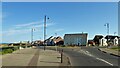
Roundabout at approach to North Road
Image: © Kevin Waterhouse
Taken: 14 Jun 2023
0.05 miles
2
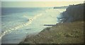
Coast at Seaham, 1967
Looking southeast from the car park above the mouth of Seaham Dene, towards Featherbed Rocks and Seaham harbour. None of the groynes seem to exist anymore.
Image: © Derek Harper
Taken: Unknown
0.06 miles
3
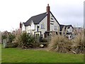
The Crow's Nest, East Shore, Seaham
A new pub built as part of the East Shore development on the site of the old Vane Tempest Colliery Image
Image: © Andrew Curtis
Taken: 12 Feb 2010
0.06 miles
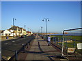
4
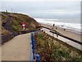
Seaham promenade
This walkway climbs up from Seaham north promenade, which doubles as a coastal defence wall just above beach level, up to North Road.
Image: © Andrew Curtis
Taken: 9 Oct 2009
0.06 miles
5
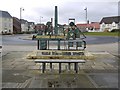
Vane Tempest Colliery interpretive sculpture, Seaham
Viewed in this direction, towards the roundabout leading to a new housing estate, where the main gates of Vane Tempest Colliery once stood, Michael Johnson's sculpture shows the profile of the old colliery buildings which would have dominated the landscape. There was a tall central chimney flanked by the pit head gear above each of the two shafts, called Vane & Tempest, and the accompanying buildings which housed the winding gear and engines http://www.east-durham.co.uk/seaham/vanetempest/pages/image/imagepage4.html
Image: © Andrew Curtis
Taken: 12 Feb 2010
0.07 miles
6

Vane Tempest Colliery interpretive sculpture, Seaham
The metal inlays in the ground represent the underground roadways of 'C' seam worked from Vane Tempest Colliery between 1985 and 1993 leading from the two shafts descending, symbolically, from the seat.
"You were working two, three miles out to sea. You were nearly an hour underground before you got started"
"There were roads running all ways. Countless miles of roads. Add them together and they'd stretch to London"
Image: © Andrew Curtis
Taken: 12 Feb 2010
0.07 miles
7
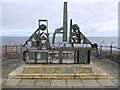
Vane Tempest Colliery interpretive sculpture, Seaham
Another sculpture by Michael Johnson on the Seaham time-line. It is located opposite the old Vane Tempest Main Gates, now a roundabout leading to a new housing estate.
This one represents the skyline profile of the Vane Tempest Colliery buildings. Beyond the sculpture is a seat from where metal inlays on the ground represent the miles of tunnels that ran from the main shafts far below the sea-bed. Around the base are interpretive panels.
There were once three pits in the immediate area: Seaham Colliery closed in March 1986, Dawdon Colliery in July 1991, and Vane Tempest Colliery in June 1993.
Image: © Andrew Curtis
Taken: 12 Feb 2010
0.07 miles
8
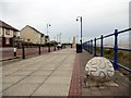
North Road, Seaham
Stone carvings and other sculptures with a marine theme ornament the revamped upper promenade.
Image: © Andrew Curtis
Taken: 9 Oct 2009
0.07 miles
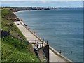
10
Coast Road, Seaham
It was early in the morning on a beautiful September day. The view was spectacular up to Sunderland and beyond.
Image: © Irene Marlborough
Taken: 11 Sep 2007
0.08 miles