IMAGES TAKEN NEAR TO
Benevente Street, SEAHAM, SR7 7TJ
Introduction
This page details the photographs taken nearby to Benevente Street, SR7 7TJ by members of the Geograph project.
The Geograph project started in 2005 with the aim of publishing, organising and preserving representative images for every square kilometre of Great Britain, Ireland and the Isle of Man.

There are currently over 7.5m images from over14,400 individuals and you can help contribute to the project by visiting https://www.geograph.org.uk
Image Map
Images are licensed for reuse under creativecommons.org/licenses/by-sa/2.0
Notes
- Clicking on the map will re-center to the selected point.
- The higher the marker number, the further away the image location is from the centre of the postcode.
Image Listing (20 Images Found)
Images are licensed for reuse under creativecommons.org/licenses/by-sa/2.0
Image
Details
Distance
1
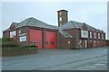
Seaham fire station
Seaham fire station, Parkside Road, Seaham, County Durham
Image: © Kevin Hale
Taken: 27 Nov 2006
0.12 miles
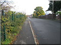
3
County Durham and Darlington Fire and Rescue Station Seaham
Image: © Peter Robinson
Taken: 9 Nov 2010
0.13 miles
4
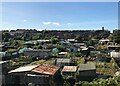
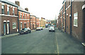
Allotments At Dawdon
Allotment gardens in front of colliery rows at Dawdon. Dawdon Colliery was one of the last to close in the Durham coalfield.
Image: © David Robinson
Taken: 20 Sep 2021
0.15 miles
5
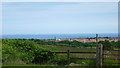
Seaham from West Farm
Seaham fire station tower poking above the houses. The North Sea is in the background
Image: © Richard Cooke
Taken: 15 Jun 2010
0.15 miles
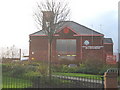
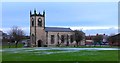
7
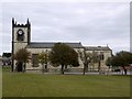
Parish Church of St John the Evangelist
Parish church. 1835-40 by Thomas Prosser, north aisle added 1860, choir and vicar's vestries added by R.J. Johnson in 1885-6. Dressed limestone with sandstone dressings and moderate-pitched graduated Welsh slate roofs. West tower, aisleless nave and chancel, north aisle, north choir and vicar's vestries. Perpendicular style. Windows have mainly rectilinear tracery with trefoil-headed lights, chamfered reveals, hoodmoulds and alternating jambs.
See description here: https://keystothepast.info/search-records/results-of-search/results-of-search-2/site-details/?PRN=D36106 https://web.archive.org/web/20221119095506/https://keystothepast.info/search-records/results-of-search/results-of-search-2/site-details/?PRN=D36106
Image: © Andrew Curtis
Taken: 9 Oct 2009
0.20 miles
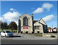
8
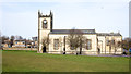
Church of St John the Evangelist
The church as seen from the south over a grassed field which once was the graveyard but the monuments have been removed due to instability and are arranged around and against the perimeter wall.
Image: © Trevor Littlewood
Taken: 14 Feb 2019
0.21 miles
9
Parish Church of St.John's, New Seaham
Built in 1857 due to the rapid expansion of New Seaham and the inability of the old Church of St.Mary's to be able to cope with all the extra burials.
To give some idea of this, the parish census for Seaham in 1841 was 153, by 1851 it was at 729, by 1861 it was an incredible 2591, and by 1891 it was close to 4800 souls.
Image: © Matthew Hatton
Taken: 16 Jan 2016
0.21 miles
10
Parish Church of St John the Evangelist, Seaham
The Grade II listed https://historicengland.org.uk/listing/the-list/list-entry/1277262?section=official-list-entry church by Thomas Prosser dates from 1840. The north aisle was added in 1860 and the choir and vicar's vestries were added by R.J.Johnson in 1885-6.
An historic timeline can be found on the church website: https://stjohns-seaham.org.uk/church-history
Image: © Gerald England
Taken: 18 Oct 2022
0.21 miles