IMAGES TAKEN NEAR TO
Alfred Street East, SEAHAM, SR7 7LA
Introduction
This page details the photographs taken nearby to Alfred Street East, SR7 7LA by members of the Geograph project.
The Geograph project started in 2005 with the aim of publishing, organising and preserving representative images for every square kilometre of Great Britain, Ireland and the Isle of Man.

There are currently over 7.5m images from over14,400 individuals and you can help contribute to the project by visiting https://www.geograph.org.uk
Image Map
Images are licensed for reuse under creativecommons.org/licenses/by-sa/2.0
Notes
- Clicking on the map will re-center to the selected point.
- The higher the marker number, the further away the image location is from the centre of the postcode.
Image Listing (24 Images Found)
Images are licensed for reuse under creativecommons.org/licenses/by-sa/2.0
Image
Details
Distance

3
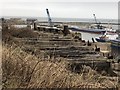
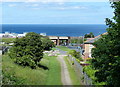
Disused Railway, Seaham Harbour
Seaham harbour had an extensive and complicated railway system up until the second half of the 20th century. The railway operated on two levels, the upper level bringing in goods (primarily coal) for loading onto ships via staiths, while the lower level allowed access to the dockside. The image shows the remains of a gantry supporting railway sleepers at the southern end of the harbour for the upper level rail complex.
Image: © David Robinson
Taken: 3 Mar 2019
0.10 miles
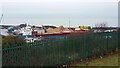
6
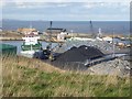
Seaham Harbour
The Imke, a small container ship of 3990 gross tonnage, next to piles of what appear to be coal and scrap metal.
Image: © Oliver Dixon
Taken: 10 Feb 2016
0.14 miles
8
Seaham Harbour -- Ship being Unloaded.
It looks like sand being unloaded which seems strange considering all the sand that's available on the coast. In some areas such as South Shields taking sand form the beaches is illegal. BUT is it the right type of sand that is available locally. There were similar problems with cola many years ago. Local cola wasn't suitable for the power station at Blyth so it was shipped in!
Image: © Les Hull
Taken: 22 Feb 2021
0.15 miles