IMAGES TAKEN NEAR TO
Tees Street, SEAHAM, SR7 7DE
Introduction
This page details the photographs taken nearby to Tees Street, SR7 7DE by members of the Geograph project.
The Geograph project started in 2005 with the aim of publishing, organising and preserving representative images for every square kilometre of Great Britain, Ireland and the Isle of Man.

There are currently over 7.5m images from over14,400 individuals and you can help contribute to the project by visiting https://www.geograph.org.uk
Image Map
Images are licensed for reuse under creativecommons.org/licenses/by-sa/2.0
Notes
- Clicking on the map will re-center to the selected point.
- The higher the marker number, the further away the image location is from the centre of the postcode.
Image Listing (117 Images Found)
Images are licensed for reuse under creativecommons.org/licenses/by-sa/2.0
Image
Details
Distance
1
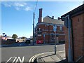
The Inn Between
On the corner of South Railway Street and Adelaide Row. Originally a Newcastle Breweries pub and previously named the Masons Arms (1831-1861) and Northumberland Arms. It acquired the name The Inn Between in the 1980s. It was refurbished and opened up in 2020 after being closed and boarded up for ten years.
Image
Image: © Gerald England
Taken: 18 Oct 2022
0.05 miles
2
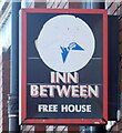
Sign of the Inn Between
Sign for the Inn Between Image
Image: © Gerald England
Taken: 18 Oct 2022
0.05 miles
3
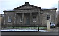
The Londonderry Institute
Former Literary and Scientific Institute. 1853-5 by Thomas Oliver.
Grade 2 Listed. It was used as a parish room by the St. John's Church Men's Room Committee in 1914. It is a handsome structure of freestone of the Grecian Doric order, and cost £2000 to build.
Image: © Matthew Hatton
Taken: 16 Jan 2016
0.07 miles
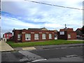
5
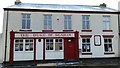
The Duke of Seaham
The internals of this public house seem to have been gutted and the building is beginning to look a little forlorn. It is my understanding that this was previously known as the Duke of Wellington. It was so named after the Duke of Wellington himself visited the Londonderry's at there family seat in Seaham Hall around 1827. It is on South Railway Street.
Image: © Matthew Hatton
Taken: 16 Jan 2016
0.08 miles
6
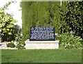
HMS Seaham Memorial
A black marble plaque was unveiled in 2017 in the Clock Garden in memory of the crew of HMS Seaham https://uboat.net/allies/warships/ship/3190.html At top left is the badge of HMS Seaham. The text reads:
DEDICATED TO THE SHIPS COMPANY
WHO CARRIED THE TOWNS NAME
IN THE SERVICE OF OUR COUNTRY
HMS SEAHAM WAS A BANGOR CLASS
MINESWEEPER, COMMISSIONED AND FUNDED
BY THE PEOPLE OF SEAHAM DURING THE
SECOND WORLD WAR. THIS SHIP HAD
A GLORIOUS AND DISTINCTIVE WAR RECORD,
CARRYING OUT ESCORT DUTIES FOR CONVOYS,
AND MORE NOTABLE AS. A MINESWEEPER.
HMS SEAHAM WAS ALSO INVOLVED IN THE
DANGEROUS TASK OF CLEARING OF SHIPPING
LINES PRIOR TO THE D DAY LANDING IN 1944.
unveiled by Rt Hon G Morris 2017.
North East War Memorials Project: http://www.newmp.org.uk/detail.php?contentId=11613
Image: © Gerald England
Taken: 18 Oct 2022
0.10 miles
7
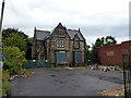
Rock House, Tempest Road, Seaham
Built in the mid-19th century, Rock House became a community centre in 1931. It doesn't appear to be listed and the site was recently offered for sale at £160,000. The house now appears to be in very poor condition.
Image: © John Lucas
Taken: 8 Jul 2014
0.10 miles
8
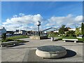
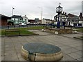
Clock Garden
The Clock Garden is home to a number of memorials, including, on the right, one to the crew of HMS Seaham Image
The bronze plaque in the foreground shows the plans drawn up for Seaham by the architect John Dobson for local developer Charles Stewart, the 3rd Marquess of Londonderry. Shortage of money after developing the harbour and railway connection meant that only a few of the elaborate buildings in this area of the town could actually be built. Image
The clock in the background was erected to celebrate the millennium. Image
Image: © Gerald England
Taken: 18 Oct 2022
0.10 miles
9
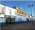
Valentes Seaham
The cafe on Church Street was established in 1920 and was originally an ice cream parlour. Woolworths opened next door in 1936. It closed in 1989 and for a time was an Ethel Austin shop. More recently it has housed a charity shop.
Image: © Gerald England
Taken: 18 Oct 2022
0.10 miles
10
Terrace Green, Seaham
The bronze plaque in the foreground shows the plans drawn up for Seaham by the architect John Dobson for local developer Charles Stewart, the 3rd Marquess of Londonderry. Shortage of money after developing the harbour and railway connection meant that only a few of the elaborate buildings in this area of the town could actually be built.
Image: © Andrew Curtis
Taken: 9 Oct 2009
0.10 miles