IMAGES TAKEN NEAR TO
Brookside Villas, Dene House Road, SEAHAM, SR7 7BG
Introduction
This page details the photographs taken nearby to Brookside Villas, Dene House Road, SR7 7BG by members of the Geograph project.
The Geograph project started in 2005 with the aim of publishing, organising and preserving representative images for every square kilometre of Great Britain, Ireland and the Isle of Man.

There are currently over 7.5m images from over14,400 individuals and you can help contribute to the project by visiting https://www.geograph.org.uk
Image Map
Images are licensed for reuse under creativecommons.org/licenses/by-sa/2.0
Notes
- Clicking on the map will re-center to the selected point.
- The higher the marker number, the further away the image location is from the centre of the postcode.
Image Listing (99 Images Found)
Images are licensed for reuse under creativecommons.org/licenses/by-sa/2.0
Image
Details
Distance
1
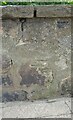
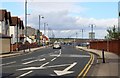
Seaham, North Road
Benchmark on perimeter wall of house, 2 residences to left of Masonic Hall
Image: © Mel Towler
Taken: 15 May 2021
0.01 miles
2
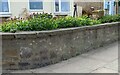
Seaham, North Road
Wider view of located benchmark on perimeter wall - 1914 map says 68ft above sea level.
Image: © Mel Towler
Taken: 15 May 2021
0.01 miles
5
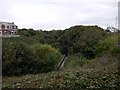
Rockhouse Dene, Seaham
Managed as a Local Nature Reserve, this steep-sided valley in the centre of Seaham provides woodland, grassland and stream-side wildlife habitats
http://www.danmyers.dsl.pipex.com/DCCDanMwebsite_files/page0011.htm
Image: © Andrew Curtis
Taken: 9 Oct 2009
0.04 miles
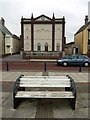
6
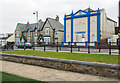
Unity Lodge of Mark Master Masons
The Unity Lodge of Mark Master Masons is the formal name given to the strikingly decorated masonic lodge on North Road, Seaham. It has the appearance of an old Methodist chapel and perhaps, once was one.
Image: © Trevor Littlewood
Taken: 20 Feb 2018
0.04 miles
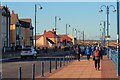
7
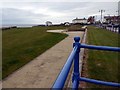
Cliff top green, Seaham
The green is above the promontory at Featherbed Rocks. The white building just right of middle is Bath Terrace, 4 houses in a terrace built around 1830. It now seems a little near the cliff edge. The small building to the left is the Coastguard Station.
Image: © Andrew Curtis
Taken: 9 Oct 2009
0.06 miles
8
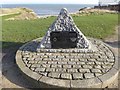
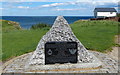
George Elmy Memorial, Seaham
This memorial was erected in 1994. The inscription reads:
Remember the Heroes.
This Memorial is to commemorate the bravery of the five lifeboat men who lost their lives when, in the stormy seas on November 17th 1962, the Seaham Lifeboat George Elmy capsized with the loss of its crew...
and all but one of the crew of the fishing coble Economy to whose aid the courageous men had gone...
"Greater love hath no man than this, that a man lay down his life for his friends"
The George Elmy is also commemorated in the new Top Dock Road a short way to the south Image
Image: © Oliver Dixon
Taken: 16 Feb 2016
0.06 miles
10
George Elmy Lifeboat Memorial, Seaham
For more info:
Image
Image: © Mat Fascione
Taken: 24 Jun 2017
0.07 miles