IMAGES TAKEN NEAR TO
Tempest Road, SEAHAM, SR7 7AY
Introduction
This page details the photographs taken nearby to Tempest Road, SR7 7AY by members of the Geograph project.
The Geograph project started in 2005 with the aim of publishing, organising and preserving representative images for every square kilometre of Great Britain, Ireland and the Isle of Man.

There are currently over 7.5m images from over14,400 individuals and you can help contribute to the project by visiting https://www.geograph.org.uk
Image Map
Images are licensed for reuse under creativecommons.org/licenses/by-sa/2.0
Notes
- Clicking on the map will re-center to the selected point.
- The higher the marker number, the further away the image location is from the centre of the postcode.
Image Listing (119 Images Found)
Images are licensed for reuse under creativecommons.org/licenses/by-sa/2.0
Image
Details
Distance
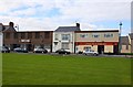
1
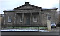
The Londonderry Institute
Former Literary and Scientific Institute. 1853-5 by Thomas Oliver.
Grade 2 Listed. It was used as a parish room by the St. John's Church Men's Room Committee in 1914. It is a handsome structure of freestone of the Grecian Doric order, and cost £2000 to build.
Image: © Matthew Hatton
Taken: 16 Jan 2016
0.01 miles
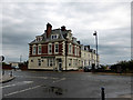
3
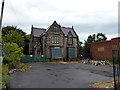
Rock House, Tempest Road, Seaham
Built in the mid-19th century, Rock House became a community centre in 1931. It doesn't appear to be listed and the site was recently offered for sale at £160,000. The house now appears to be in very poor condition.
Image: © John Lucas
Taken: 8 Jul 2014
0.06 miles
4
Ex Vane-Tempest owned houses in Tempest Road, Seaham
In the 1860s, my great, great-grandfather was a coal agent working for the Londonderry mines at Seaham and he and his family lived in the 2nd house from the right. At that time there were only two houses, those on the left being built subsequently. The slightly different brick colour can still be discerned. Tempest Road was then Tempest Place.
Image: © John Lucas
Taken: 8 Jul 2014
0.09 miles
5
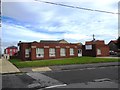
Clubs on North Terrace
Seaham Ex-Naval Club and Harley's Bar & Snooker Club on North Terrace.
Image: © Steve Daniels
Taken: 20 Sep 2011
0.10 miles

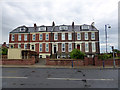
7
Bath Terrace, Seaham
Advertised for tenants in the Durham Chronicle when constructed in 1848. Still among the best blocks of houses in the town 145 years later. Designed by the Newcastle architect Dobson. Grade II listed.
Image: © John Lucas
Taken: 8 Jul 2014
0.11 miles
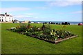
9
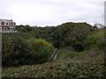
Rockhouse Dene, Seaham
Managed as a Local Nature Reserve, this steep-sided valley in the centre of Seaham provides woodland, grassland and stream-side wildlife habitats
http://www.danmyers.dsl.pipex.com/DCCDanMwebsite_files/page0011.htm
Image: © Andrew Curtis
Taken: 9 Oct 2009
0.11 miles
10
The Inn Between
On the corner of South Railway Street and Adelaide Row. Originally a Newcastle Breweries pub and previously named the Masons Arms (1831-1861) and Northumberland Arms. It acquired the name The Inn Between in the 1980s. It was refurbished and opened up in 2020 after being closed and boarded up for ten years.
Image
Image: © Gerald England
Taken: 18 Oct 2022
0.11 miles