IMAGES TAKEN NEAR TO
Hall Dene Way, SEAHAM, SR7 0PU
Introduction
This page details the photographs taken nearby to Hall Dene Way, SR7 0PU by members of the Geograph project.
The Geograph project started in 2005 with the aim of publishing, organising and preserving representative images for every square kilometre of Great Britain, Ireland and the Isle of Man.

There are currently over 7.5m images from over14,400 individuals and you can help contribute to the project by visiting https://www.geograph.org.uk
Image Map
Images are licensed for reuse under creativecommons.org/licenses/by-sa/2.0
Notes
- Clicking on the map will re-center to the selected point.
- The higher the marker number, the further away the image location is from the centre of the postcode.
Image Listing (6 Images Found)
Images are licensed for reuse under creativecommons.org/licenses/by-sa/2.0
Image
Details
Distance
1
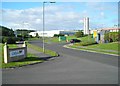
Shiny silos at Seaham Grange Industrial Estate
Image: © Antony Dixon
Taken: 14 Sep 2012
0.09 miles
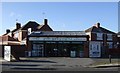
4
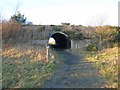
Subway under the A1018
This subway under the northbound carriageway of the A1018 carries a cycle route which links the town of Seaham with National Cycle Network route 1. http://www.sustrans.org.uk/default.asp?sID=1089735289781 Unfortunately the last 100m of the route (just the far side of the subway) is a muddy field-edge path which very much detracts from the value of the link.
Image: © Oliver Dixon
Taken: 16 Jan 2007
0.22 miles
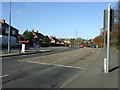
5
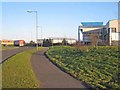
Seaham Grange Industrial Estate
http://www.easington.gov.uk/services/regenpart/business/grangefs.asp
Image: © Oliver Dixon
Taken: 16 Jan 2007
0.22 miles