IMAGES TAKEN NEAR TO
Norfolk Close, SEAHAM, SR7 0EA
Introduction
This page details the photographs taken nearby to Norfolk Close, SR7 0EA by members of the Geograph project.
The Geograph project started in 2005 with the aim of publishing, organising and preserving representative images for every square kilometre of Great Britain, Ireland and the Isle of Man.

There are currently over 7.5m images from over14,400 individuals and you can help contribute to the project by visiting https://www.geograph.org.uk
Image Map
Images are licensed for reuse under creativecommons.org/licenses/by-sa/2.0
Notes
- Clicking on the map will re-center to the selected point.
- The higher the marker number, the further away the image location is from the centre of the postcode.
Image Listing (9 Images Found)
Images are licensed for reuse under creativecommons.org/licenses/by-sa/2.0
Image
Details
Distance
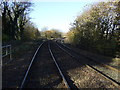
1
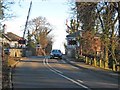
Hall Dene railway station (site), County Durham
Opened in 1875 by the Londonderry Seaham & Sunderland Railway, later part of the North Eastern Railway, on what is today the line from Stockton to Sunderland, this private station for the Londonderry family closed in 1923.
View north towards Ryhope and Sunderland, from a passing train. The station was also known as Seaham Hall station.
Image: © Nigel Thompson
Taken: 8 May 2010
0.19 miles
2
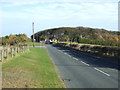
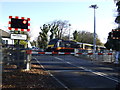
Halldene Level Crossing
Where the Durham Coast railway crosses Lord Byron's Walk (Lord Byron had connections with Seaham Hall Image]).
Image: © Oliver Dixon
Taken: 16 Jan 2007
0.20 miles
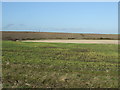
3
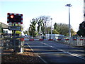
Level crossing on Lord Byrons Walk
Southbound Grand Central train passing.
Image: © JThomas
Taken: 10 Nov 2012
0.21 miles

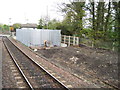
6
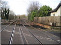
Hall Dene railway station (site), County Durham
Opened in 1875 by the Londonderry Seaham & Sunderland Railway, later part of the North Eastern Railway, on what is today the line from Stockton to Sunderland, this private station for the Londonderry family closed in 1923.
View north towards Ryhope and Sunderland from the level crossing. The station was also known as Seaham Hall station.
Image: © Nigel Thompson
Taken: 10 Jan 2017
0.22 miles