IMAGES TAKEN NEAR TO
Durham Street, SEAHAM, SR7 0DW
Introduction
This page details the photographs taken nearby to Durham Street, SR7 0DW by members of the Geograph project.
The Geograph project started in 2005 with the aim of publishing, organising and preserving representative images for every square kilometre of Great Britain, Ireland and the Isle of Man.

There are currently over 7.5m images from over14,400 individuals and you can help contribute to the project by visiting https://www.geograph.org.uk
Image Map
Images are licensed for reuse under creativecommons.org/licenses/by-sa/2.0
Notes
- Clicking on the map will re-center to the selected point.
- The higher the marker number, the further away the image location is from the centre of the postcode.
Image Listing (6 Images Found)
Images are licensed for reuse under creativecommons.org/licenses/by-sa/2.0
Image
Details
Distance
5
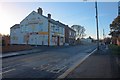
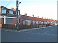
The Kestrel
Former pub in a new life as a convenience store. On Station Road.
Image: © Mick Garratt
Taken: 7 Nov 2013
0.23 miles
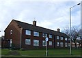
6
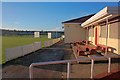
Seaham Harbour Cricket Club
"Establish in 1868 by the Londonderry Coal Company for their staff, the community of Seaham Harbour and in 1931 the management and miners of Vane Tempest Colliery."
According to a blue plaque on the wall.
Image: © Mick Garratt
Taken: 7 Nov 2013
0.25 miles