IMAGES TAKEN NEAR TO
Riddings Square, SUNDERLAND, SR5 5LT
Introduction
This page details the photographs taken nearby to Riddings Square, SR5 5LT by members of the Geograph project.
The Geograph project started in 2005 with the aim of publishing, organising and preserving representative images for every square kilometre of Great Britain, Ireland and the Isle of Man.

There are currently over 7.5m images from over14,400 individuals and you can help contribute to the project by visiting https://www.geograph.org.uk
Image Map
Images are licensed for reuse under creativecommons.org/licenses/by-sa/2.0
Notes
- Clicking on the map will re-center to the selected point.
- The higher the marker number, the further away the image location is from the centre of the postcode.
Image Listing (6 Images Found)
Images are licensed for reuse under creativecommons.org/licenses/by-sa/2.0
Image
Details
Distance
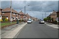
2
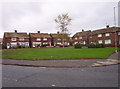
Ravenswood Road
Houses on the corner of Ravenswood Road and Rotherfield Road on the Hylton Red House estate.
Image: © Weston Beggard
Taken: 4 Dec 2005
0.22 miles
3
Hylton Red House
Housing on Hylton Red House estate.
Image: © Weston Beggard
Taken: 4 Dec 2005
0.22 miles
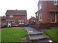
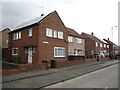
4
Ribble Road
They look like Semis but these houses share common entry halls making them pure Double-Ribblers.
Image: © MSX
Taken: 4 Dec 2005
0.22 miles
5
Runnymede Road
Hylton Red House.
The Red House was a farm, it is shown far outwith the urban area on the 1951 OS 1:25,000 Provisional edition map.
Image: © Richard Webb
Taken: 9 Aug 2016
0.23 miles
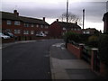
6
Houses on Rochdale Road
Hylton Red House area of Sunderland.
Image: © JThomas
Taken: 18 Aug 2018
0.24 miles