IMAGES TAKEN NEAR TO
Hylton Road, SUNDERLAND, SR4 9AJ
Introduction
This page details the photographs taken nearby to Hylton Road, SR4 9AJ by members of the Geograph project.
The Geograph project started in 2005 with the aim of publishing, organising and preserving representative images for every square kilometre of Great Britain, Ireland and the Isle of Man.

There are currently over 7.5m images from over14,400 individuals and you can help contribute to the project by visiting https://www.geograph.org.uk
Image Map
Images are licensed for reuse under creativecommons.org/licenses/by-sa/2.0
Notes
- Clicking on the map will re-center to the selected point.
- The higher the marker number, the further away the image location is from the centre of the postcode.
Image Listing (8 Images Found)
Images are licensed for reuse under creativecommons.org/licenses/by-sa/2.0
Image
Details
Distance
1
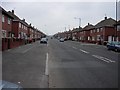
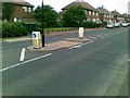
A Long Road
Hylton Road, running through Pennywell in Sunderland.
Image: © Brian Abbott
Taken: 12 May 2006
0.03 miles
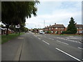
2
Houses on Hylton Road, Pennywell, Sunderland
Image: © JThomas
Taken: 18 Aug 2018
0.09 miles
3
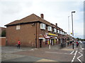
Post Office and shop on Hylton Road, Pennywell, Sunderland
Image: © JThomas
Taken: 18 Aug 2018
0.10 miles
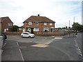
4
Hylton Road, Pennywell, Sunderland
Looking north east.
Image: © JThomas
Taken: 18 Aug 2018
0.16 miles
6
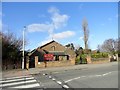
St Anne's R C Church, Pennywell
Pennywell was built as a large council housing estate on the western edge of Sunderland in the early 1950's. This church was built to serve the estate in 1957 to a modern design by Matkin and Hawkins of Sunderland.
Image: © Robert Graham
Taken: 20 Feb 2018
0.21 miles
7
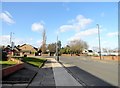
Top of Portsmouth Road, Pennywell
In the western suburbs of Sunderland. This is the north end of Portsmouth Road, at the junction with Hylton Road. On the left is St Anne's R C Church.
Image: © Robert Graham
Taken: 20 Feb 2018
0.22 miles
8
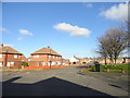
Junction of Palmstead Road with Portsmouth Road
These are on the Pennywell estate on the west side of Sunderland. This large estate was built in the early 1950's as council housing. Virtually every street name begins with a P.
Image: © Robert Graham
Taken: 20 Feb 2018
0.24 miles