IMAGES TAKEN NEAR TO
Hylton Road, SUNDERLAND, SR4 7YF
Introduction
This page details the photographs taken nearby to Hylton Road, SR4 7YF by members of the Geograph project.
The Geograph project started in 2005 with the aim of publishing, organising and preserving representative images for every square kilometre of Great Britain, Ireland and the Isle of Man.

There are currently over 7.5m images from over14,400 individuals and you can help contribute to the project by visiting https://www.geograph.org.uk
Image Map
Images are licensed for reuse under creativecommons.org/licenses/by-sa/2.0
Notes
- Clicking on the map will re-center to the selected point.
- The higher the marker number, the further away the image location is from the centre of the postcode.
Image Listing (26 Images Found)
Images are licensed for reuse under creativecommons.org/licenses/by-sa/2.0
Image
Details
Distance
1
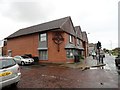
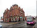
City Life Church, Sunderland
A contemporary style church on Hylton Road.
Image: © Robert Graham
Taken: 19 May 2017
0.02 miles
2
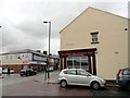
Junction of John Candlish Road with Hylton Road
In the Millfield area of Sunderland. Juhn Candlish was a C19 industrialist who operated a large bottle works in Millfield, and became Lord Mayor and MP for Sunderland.
Image: © Robert Graham
Taken: 19 May 2017
0.02 miles
3
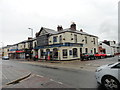
The Willow Pond pub
West of Sunderland city centre. On Hylton Road, at the junction with Gilsland Street
Image: © Robert Graham
Taken: 19 May 2017
0.03 miles
4
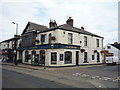
The Willow Pond public house, Sunderland
On Hylton Road.
Image: © JThomas
Taken: 18 Aug 2018
0.03 miles
5
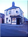
The Mountain Daisy
Big, old pub in the Millfield area of Sunderland. On the corner of Hylton Road and Cromwell Street.
Image: © Robert Graham
Taken: 19 May 2017
0.07 miles
6
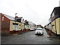
Sunderland Cottages on Cromwell Street
In the Millfield area of the city. This distinct style of terraced single storey cottages were built in large numbers in Sunderland in the C19 and early C20.
Image: © Robert Graham
Taken: 19 May 2017
0.10 miles
7
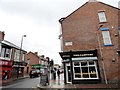
Junction of Rutland Street and Hylton Road, Sunderland
Looking west along Hylton Road. In the western part of the city.
Image: © Robert Graham
Taken: 19 May 2017
0.13 miles
8
Railway tavern, Hylton Road, Sunderland
Image: © Freethinker
Taken: 21 Jan 2009
0.13 miles
9
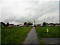
Diamond Hall Pocket Park
Small public park in the Millfield area of Sunderland. It was created on the site of a former Infants School.
Image: © Robert Graham
Taken: 19 May 2017
0.14 miles
10
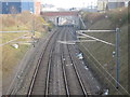
Millfield 2nd railway station (site), Tyne and Wear
Opened in 1890 by the North Eastern Railway on the line from Durham to Sunderland, this station replaced an earlier one on the far side of the bridge. It in turn closed to passengers in 1955.
View south east towards University and Sunderland. A Metro station was opened on the site of the original railway station in 2002, visible beyond the bridge.
Image: © Nigel Thompson
Taken: 24 Mar 2012
0.14 miles