IMAGES TAKEN NEAR TO
Faraday Grove, SUNDERLAND, SR4 6UL
Introduction
This page details the photographs taken nearby to Faraday Grove, SR4 6UL by members of the Geograph project.
The Geograph project started in 2005 with the aim of publishing, organising and preserving representative images for every square kilometre of Great Britain, Ireland and the Isle of Man.

There are currently over 7.5m images from over14,400 individuals and you can help contribute to the project by visiting https://www.geograph.org.uk
Image Map
Images are licensed for reuse under creativecommons.org/licenses/by-sa/2.0
Notes
- Clicking on the map will re-center to the selected point.
- The higher the marker number, the further away the image location is from the centre of the postcode.
Image Listing (27 Images Found)
Images are licensed for reuse under creativecommons.org/licenses/by-sa/2.0
Image
Details
Distance
1

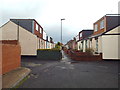
Faraday Grove, Sunderland
Faraday Grove is a residential road in the suburbs of Sunderland.
Image: © Malc McDonald
Taken: 27 Oct 2018
0.08 miles
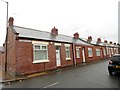
2

Bancroft Terrace, Sunderland
Bancroft Terrace is flanked on one side by a row of Sunderland cottages.
Image: © Malc McDonald
Taken: 27 Oct 2018
0.10 miles
3
Westwood Street, Sunderland
Westwood Street in Sunderland's suburbs.
The street is a path flanked on either side by a terrace of Sunderland cottages. Although these were built as single-storey dwellings, many have had their loft space converted into additional living space.
Image: © Malc McDonald
Taken: 27 Oct 2018
0.11 miles
4

Fordland Place, Sunderland
Fordland Place is a residential road in Sunderland.
Image: © Malc McDonald
Taken: 27 Oct 2018
0.11 miles
5
Brookland Road, Sunderland
Brookland Road, in the suburbs of Sunderland. The road is flanked by a terrace of single-storey Sunderland cottages.
This image was taken in late October. Leaves on the tree in the centre of the image had turned golden.
Image: © Malc McDonald
Taken: 27 Oct 2018
0.12 miles
6
Erith Terrace, Sunderland
Erith Terrace is a residential street in Sunderland.
Image: © Malc McDonald
Taken: 27 Oct 2018
0.12 miles
7
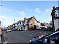
Terraced houses on Hylton Road
The houses are Whitehall Terrace, with Brookland Road running off to the right. These streets on the south side of Hylton Road are late Victorian in date. Part of the Ford suburb on the western side of Sunderland.
Image: © Robert Graham
Taken: 20 Feb 2018
0.13 miles
8

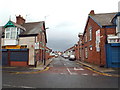
Looking west along Hylton Road, Sunderland
West of the city centre. View from the junction with Pallion Road.
Image: © Robert Graham
Taken: 19 May 2017
0.13 miles
9

View north along Pallion Road , Sunderland
From the junction with Hylton Road.
Image: © Robert Graham
Taken: 19 May 2017
0.14 miles
10
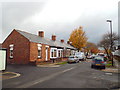
Hazeldene Terrace off Pallion Road
In the western suburbs of the city. This street is a great example of the Sunderland Cottage, a distinct type of terraced bungalow built in large numbers from the C19 to the C20 in the city.
Image: © Robert Graham
Taken: 19 May 2017
0.14 miles