IMAGES TAKEN NEAR TO
Pallion New Road, SUNDERLAND, SR4 6UA
Introduction
This page details the photographs taken nearby to Pallion New Road, SR4 6UA by members of the Geograph project.
The Geograph project started in 2005 with the aim of publishing, organising and preserving representative images for every square kilometre of Great Britain, Ireland and the Isle of Man.

There are currently over 7.5m images from over14,400 individuals and you can help contribute to the project by visiting https://www.geograph.org.uk
Image Map
Images are licensed for reuse under creativecommons.org/licenses/by-sa/2.0
Notes
- Clicking on the map will re-center to the selected point.
- The higher the marker number, the further away the image location is from the centre of the postcode.
Image Listing (33 Images Found)
Images are licensed for reuse under creativecommons.org/licenses/by-sa/2.0
Image
Details
Distance
1

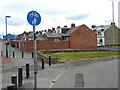
New Pallion Road
The Weardale Way follows the pavement down this road, classified as the B1405. The long distance footpath has been gradually diminishing in importance as it enters the precincts of Sunderland. Signposts that were once abundant, have now totally disappeared as this point is reached. It seems it no longer exists.
Image: © Chris Heaton
Taken: 19 May 2023
0.10 miles
2

A colourful subway
Very colourful graffiti on the subway under the South Hylton branch of the Metro leading to Lisburn Terrace.
Image: © Oliver Dixon
Taken: 19 Jun 2015
0.10 miles
3

A colourful subway
Very colourful graffiti on the subway under the South Hylton branch of the Metro leading from Lisburn Terrace to Millfield.
Image: © Oliver Dixon
Taken: 19 Jun 2015
0.12 miles
4

Cycle path at Pallion
This cycle path runs close to the Tyne and Wear Metro extension from Sunderland to South Hylton, opened in 2002 which makes use in the main of the line of the former Sunderland to Durham railway.
Image: © Oliver Dixon
Taken: 19 Jun 2015
0.12 miles
5
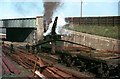
Crane locomotive at Doxford's shipyard, Sunderland, 1967
The shipyard had several of these very unusual crane-fitted locomotives, used to move material around the site. This was the upper yard, connected to the main railway system, where steel sections could be transferred down to the construction slipways. This involved a zig-zag route down the steep side of the River Wear on gradients as steep as around 1 in 25.
The visit was part of a weekend trip organised by the Liverpool University Public Transport Society to various collieries and other transport sites in the north east. No-one in the party was aware of these remarkable locomotives, but one was spotted from the other side of the river, and it was decided to make enquiries. As can be seen from the picture, we were made very welcome and able to take pictures in a variety of scenic locations. How many firms today would be willing to allow an unannounced party of students to make such a visit today?
A further interesting feature of this view is that the bridge now spans the Tyne and Wear Metro line to South Hylton.
Image: © Alan Murray-Rust
Taken: 18 Apr 1967
0.12 miles
6
Cycle routes at Millfield
From Queen Alexandra Bridge, Lisburn Terrace leads to a subway under the South Hylton Metro line, to emerge into a square from which various cycle routes diverge..
Image: © Oliver Dixon
Taken: 19 Jun 2015
0.13 miles
7

Deptford Terrace and Queen Alexandra Bridge, Sunderland
The road to the right is Deptford Terrace, which leads down to the bank of the River Wear. To the left is the Queen Alexandra Bridge which carries a road across the river. The bridge used to carry a railway, too, on a higher level above the road.
Image: © Malc McDonald
Taken: 8 Mar 2014
0.13 miles
8

SS Manxman, Pallion
The Manxman has been deteriorating on this berth for several years and despite various plans for her salvation is likely to be scrapped.
Image: © Chris Allen
Taken: 12 Feb 2000
0.13 miles
9

SS Manxman at Pallion Engineering, Sunderland
This is the former Isle of Man Steam Packet Company vessel Manxman which was photographed from inside the yard of Pallion Engineering (with permission). Although there are plans for her preservation, she is not in good condition.
Image: © Chris Allen
Taken: 4 Nov 2005
0.13 miles
10
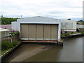
Old shipbuilding shed by the Queen Alexandra Bridge
Silting at the entrance to the lock suggests that whatever the sheds are used for now, it is not shipbuilding.
Image: © Oliver Dixon
Taken: 19 Jun 2015
0.14 miles