IMAGES TAKEN NEAR TO
Rutland Street, SUNDERLAND, SR4 6HY
Introduction
This page details the photographs taken nearby to Rutland Street, SR4 6HY by members of the Geograph project.
The Geograph project started in 2005 with the aim of publishing, organising and preserving representative images for every square kilometre of Great Britain, Ireland and the Isle of Man.

There are currently over 7.5m images from over14,400 individuals and you can help contribute to the project by visiting https://www.geograph.org.uk
Image Map
Images are licensed for reuse under creativecommons.org/licenses/by-sa/2.0
Notes
- Clicking on the map will re-center to the selected point.
- The higher the marker number, the further away the image location is from the centre of the postcode.
Image Listing (35 Images Found)
Images are licensed for reuse under creativecommons.org/licenses/by-sa/2.0
Image
Details
Distance
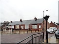
1
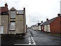
Suburban streets in Millfield, Sunderland
This is Thornbury Terrace, west of John Candlish Road. Houses are typical Sunderland Cottages.
Image: © Robert Graham
Taken: 19 May 2017
0.09 miles
2
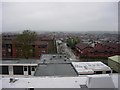
Student Accommodation
Taken from the 6th floor of the Sunderland Royal Hospital main building. Hospital buildings in the foreground. Modern student accommodation beyond that.
Image: © Brian Abbott
Taken: 14 May 2006
0.14 miles
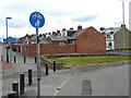
3
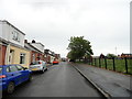
Junction of Rutland Street and Hylton Road, Sunderland
Looking west along Hylton Road. In the western part of the city.
Image: © Robert Graham
Taken: 19 May 2017
0.16 miles
4
Thornberry Street, Sunderland
A street in the Millfield district of the city. The terraced bungalows are typical Sunderland Cottages, a common building style in the city.
Image: © Robert Graham
Taken: 19 May 2017
0.16 miles
5
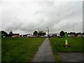
Diamond Hall Pocket Park
Small public park in the Millfield area of Sunderland. It was created on the site of a former Infants School.
Image: © Robert Graham
Taken: 19 May 2017
0.16 miles
6
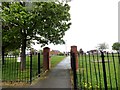
Entrance to Diamond Hall Pocket Park
Entrance on Thornbury Terrace, in the Millfield area of Sunderland. This is the only green space in a large area of dense housing.
Image: © Robert Graham
Taken: 19 May 2017
0.16 miles
7
Cottages at Martin Terrace, Sunderland
At the south end of St Luke's Terrace. A good example of the Sunderland Cottage, a distinctive style of terraced bungalows built in great numbers in the C19 & early C20.
Image: © Robert Graham
Taken: 19 May 2017
0.17 miles
8
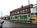
Cycle routes at Millfield
From Queen Alexandra Bridge, Lisburn Terrace leads to a subway under the South Hylton Metro line, to emerge into a square from which various cycle routes diverge..
Image: © Oliver Dixon
Taken: 19 Jun 2015
0.17 miles
9
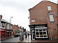
The Wear Tavern, Sunderland
On the corner of St Luke's Terrace and East Moor Road. Sadly, closed and up for sale at present, like many pubs.
Image: © Robert Graham
Taken: 19 May 2017
0.17 miles
10
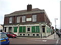
The Wear Tavern, Sunderland
Seems to be closed.
Image: © JThomas
Taken: 18 Aug 2018
0.18 miles