IMAGES TAKEN NEAR TO
Websters Bank, SUNDERLAND, SR4 6DJ
Introduction
This page details the photographs taken nearby to Websters Bank, SR4 6DJ by members of the Geograph project.
The Geograph project started in 2005 with the aim of publishing, organising and preserving representative images for every square kilometre of Great Britain, Ireland and the Isle of Man.

There are currently over 7.5m images from over14,400 individuals and you can help contribute to the project by visiting https://www.geograph.org.uk
Image Map
Images are licensed for reuse under creativecommons.org/licenses/by-sa/2.0
Notes
- Clicking on the map will re-center to the selected point.
- The higher the marker number, the further away the image location is from the centre of the postcode.
Image Listing (42 Images Found)
Images are licensed for reuse under creativecommons.org/licenses/by-sa/2.0
Image
Details
Distance
1
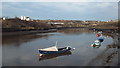
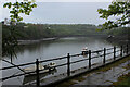
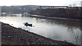
Boats on the Wear, Sunderland
The River Wear at low tide.
Image: © Malc McDonald
Taken: 8 Mar 2014
0.03 miles
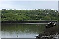
3
The River Wear
From under the Queen Alexandra bridge below Deptford Terrace.
Image: © Steve Fareham
Taken: 5 Jun 2008
0.05 miles
4
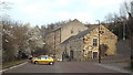
The Ropery, Sunderland
The Ropery was built in 1793, on the bank of the River Wear. It was the first factory to use machines to make rope. The building, which is Grade II listed, now houses a pub-restaurant as well as several small businesses.
This image was taken in early March 2014, as spring blossom was starting to appear on the trees.
Image: © Malc McDonald
Taken: 8 Mar 2014
0.05 miles
5
Gloomy Morning beside the River Wear
The tidal river at Deptford, Sunderland
Image: © Chris Heaton
Taken: 19 May 2023
0.06 miles
6
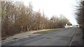
Lay by on Deptford Terrace, Sunderland
Image: © Malc McDonald
Taken: 8 Mar 2014
0.06 miles
7
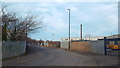
Deptford Terrace, Sunderland
Deptford Terrace runs through an industrial part of Sunderland.
Image: © Malc McDonald
Taken: 8 Mar 2014
0.07 miles
8
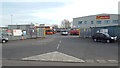
Go North East bus depot, Sunderland
Go North East's depot in Sunderland. This photo was taken on a Saturday afternoon, when most of the buses were out in service.
Image: © Malc McDonald
Taken: 8 Mar 2014
0.09 miles
9
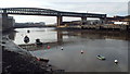
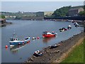
River Wear and Queen Alexandra Bridge, Sunderland
The River Wear flows into the North Sea at Sunderland. This view looks upstream, a mile or two from the mouth of the river. Here, the river is spanned by the Queen Alexandra Bridge. The bridge had two decks when it opened in 1909, with a road on the lower deck and a railway above. The railway lasted only until 1921 and has been dismantled, but the disused brick viaduct to the right of the bridge is a clue that trains once crossed the River Wear here.
More information about the Queen Alexandra Bridge can be found on the Sunderland History website http://www.sunderlandhistory.co.uk/.River-Wear-ID6/Bridges-IDS7/Queen-Alexandra-Bridge-IDI23 Forgotten Relics http://www.forgottenrelics.co.uk/bridges/gallery/queenalexandra.html and Transport Heritage http://www.transportheritage.com/find-heritage-locations.html?sobi2Task=sobi2Details&sobi2Id=90
Image: © Malc McDonald
Taken: 8 Mar 2014
0.09 miles
10
River Wear at Sunderland
This view looks upstream along the River Wear. In the background is the Queen Alexandra Bridge and behind it, a shipyard.
Image: © Malc McDonald
Taken: 8 Mar 2014
0.14 miles