IMAGES TAKEN NEAR TO
Alliance Place, SUNDERLAND, SR4 6AZ
Introduction
This page details the photographs taken nearby to Alliance Place, SR4 6AZ by members of the Geograph project.
The Geograph project started in 2005 with the aim of publishing, organising and preserving representative images for every square kilometre of Great Britain, Ireland and the Isle of Man.

There are currently over 7.5m images from over14,400 individuals and you can help contribute to the project by visiting https://www.geograph.org.uk
Image Map
Images are licensed for reuse under creativecommons.org/licenses/by-sa/2.0
Notes
- Clicking on the map will re-center to the selected point.
- The higher the marker number, the further away the image location is from the centre of the postcode.
Image Listing (22 Images Found)
Images are licensed for reuse under creativecommons.org/licenses/by-sa/2.0
Image
Details
Distance
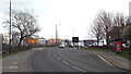
3
Beach Street, Sunderland
Despite its name, Beach Street leads not to a beach but into an industrial area on the bank of the River Wear. In this image, the Stadium of Light (football ground) and Sunderland Aquatic Centre (swimming pool) are visible. Both are on the opposite side of the river.
Image: © Malc McDonald
Taken: 8 Mar 2014
0.08 miles
4

B & Q, Warehouse, Ayre's Quay, Sunderland
Image: © Roger Cornfoot
Taken: 16 Apr 2007
0.09 miles
5
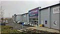
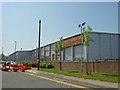
Retail park at Ayres Quay, Sunderland
Stadium of Light in background
Image: © Chris Morgan
Taken: 11 Apr 2018
0.11 miles
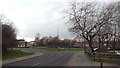
6
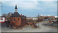
Sunderland old and new
In the foreground is a derelict industrial building and a disused road leading under a disused railway bridge. These are reminders of Sunderland's past as an industrial city. In the background to the right is the Stadium of Light, a football stadium built in the 1990s on the site of a colliery.
Image: © Malc McDonald
Taken: 8 Mar 2014
0.13 miles
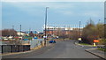
7
The rear of Halfords
From Farringdon Row.
Image: © Steve Fareham
Taken: 5 Jun 2008
0.14 miles
8
Another footpath closed, Bishopwearmouth, Sunderland
There seems to be no access to the river bank in Bishopwearmouth - presumably because of the redevelopment associated with the 'Riverside Sunderland' regeneration project
Image: © Tim Heaton
Taken: 19 May 2023
0.15 miles
9

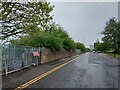
Where is the Weardale Way?
Shortly after passing The Saltgrass Inn on Hanover Place, the long distance path veers to the left towards the river - at least it is supposed to. Problem is that it has been closed off. Never mind, thought I, there is another path further up the road.
Footpath closed and entrance firmly shut of with knife like railings to ensure compliance.
No diversion signs, in fact it seems that the Weardale Way no longer exists once it reaches Sunderland.
Image: © Chris Heaton
Taken: 19 May 2023
0.15 miles
10
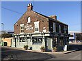
The Kings Arms
Traditional style pub that stands alone in an area of industrial units and factories.
Image: © David Robinson
Taken: 13 Feb 2023
0.16 miles