IMAGES TAKEN NEAR TO
Meadow Grove, SUNDERLAND, SR4 0JR
Introduction
This page details the photographs taken nearby to Meadow Grove, SR4 0JR by members of the Geograph project.
The Geograph project started in 2005 with the aim of publishing, organising and preserving representative images for every square kilometre of Great Britain, Ireland and the Isle of Man.

There are currently over 7.5m images from over14,400 individuals and you can help contribute to the project by visiting https://www.geograph.org.uk
Image Map
Images are licensed for reuse under creativecommons.org/licenses/by-sa/2.0
Notes
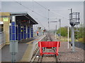
- Clicking on the map will re-center to the selected point.
- The higher the marker number, the further away the image location is from the centre of the postcode.
Image Listing (19 Images Found)
Images are licensed for reuse under creativecommons.org/licenses/by-sa/2.0
Image
Details
Distance
1
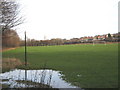
Football pitches at South Hylton Sunderland
Together with an adjacent cricket field they form a recreational area in the urban fringe of the city
Image: © Peter Robinson
Taken: 17 Jan 2010
0.14 miles
2
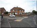
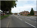
Houses on Hylton Road, Pennywell, Sunderland
Image: © JThomas
Taken: 18 Aug 2018
0.16 miles
3
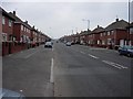
A Long Road
Hylton Road, running through Pennywell in Sunderland.
Image: © Brian Abbott
Taken: 12 May 2006
0.17 miles
4
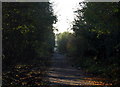
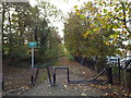
Footpath/Cycleway, South Hylton
Where the Metro line terminates the old railway route continues SW. The tunnel in the distances takes the path under the A19.
Image: © Alan Fearon
Taken: 19 Nov 2005
0.18 miles
5

Hylton railway station (site), Tyne & Wear
Opened in 1853 by the York Newcastle & Berwick Railway, later part of the North Eastern Railway, on the line from Durham to Sunderland, this station closed to passengers in 1964 and completely in 1965.
View south west towards Cox Green and Durham from the site of the level crossing. The main building was to the right, a signal box stood far left. Behind the camera position is the terminus of the Tyne & Wear Metro, now called South Hylton. See Image
For more information, see http://www.disused-stations.org.uk/h/hylton/index.shtml
Image: © Nigel Thompson
Taken: 24 Mar 2012
0.20 miles
6
Hylton Road, Pennywell, Sunderland
Looking north east.
Image: © JThomas
Taken: 18 Aug 2018
0.20 miles
7
Footpath and cycleway at South Hylton, near Sunderland
This path, shared by pedestrians and cyclists, follows the route of a former railway line.
Hylton railway station once stood on this site. There is no trace of the station visible now. Information about Hylton station, including some photographs, can be found on the Disused Stations website: http://www.disused-stations.org.uk/h/hylton/
Image: © Malc McDonald
Taken: 29 Oct 2016
0.21 miles
8
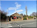
St Anne's R C Church, Pennywell
Pennywell was built as a large council housing estate on the western edge of Sunderland in the early 1950's. This church was built to serve the estate in 1957 to a modern design by Matkin and Hawkins of Sunderland.
Image: © Robert Graham
Taken: 20 Feb 2018
0.22 miles
9
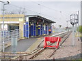
South Hylton Metro Station, Sunderland, 1st May 2006
Image: © Martin Routledge
Taken: 1 May 2006
0.22 miles
10
South Hylton Metro Station, Sunderland, 1st May 2006
Image: © Martin Routledge
Taken: 1 May 2006
0.22 miles