IMAGES TAKEN NEAR TO
St. Lukes Road, SUNDERLAND, SR4 0AL
Introduction
This page details the photographs taken nearby to St. Lukes Road, SR4 0AL by members of the Geograph project.
The Geograph project started in 2005 with the aim of publishing, organising and preserving representative images for every square kilometre of Great Britain, Ireland and the Isle of Man.

There are currently over 7.5m images from over14,400 individuals and you can help contribute to the project by visiting https://www.geograph.org.uk
Image Map
Images are licensed for reuse under creativecommons.org/licenses/by-sa/2.0
Notes
- Clicking on the map will re-center to the selected point.
- The higher the marker number, the further away the image location is from the centre of the postcode.
Image Listing (23 Images Found)
Images are licensed for reuse under creativecommons.org/licenses/by-sa/2.0
Image
Details
Distance
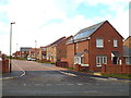
1
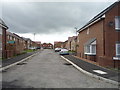
Santorin Close
New housing development off Front Road.
Road not made up yet.
Image: © JThomas
Taken: 18 Aug 2018
0.07 miles
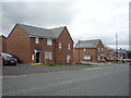
2
Gatton Close, Sunderland
Gatton Close is part of a new housing development in the Ford district of Sunderland.
Image: © Malc McDonald
Taken: 27 Oct 2018
0.08 miles
3
Front Road, Sunderland
Looking north towards the junction with St Luke's Road.
Image: © JThomas
Taken: 18 Aug 2018
0.08 miles
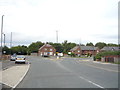
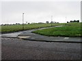
4
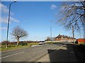
Junction on St Luke's Road
A rather complicated roundabout in the western suburbs of Sunderland. Viewed looking east, with Front Road going off to the right.
Image: © Robert Graham
Taken: 20 Feb 2018
0.08 miles
5

Flax Square, Ford
Where have all the houses gone?
Image: © Alex McGregor
Taken: 23 Aug 2010
0.08 miles
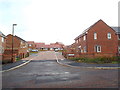
7
Santorin Close, Sunderland
Santorin Close is part of a new housing development in the Ford district of Sunderland. In this view, taken in October 2018, the road surface has not yet been finished.
Image: © Malc McDonald
Taken: 27 Oct 2018
0.09 miles
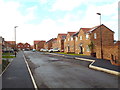
9
Sapphire Road, Sunderland
Sapphire Road forms part of a recently-built housing development in the Ford district of Sunderland.
Image: © Malc McDonald
Taken: 27 Oct 2018
0.11 miles
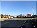
10
Looking east along St Luke's Road
In the western suburbs of Sunderland. You can just make out the support structure of the new River Wear crossing on the horizon in the centre of the picture.
Image: © Robert Graham
Taken: 20 Feb 2018
0.13 miles