IMAGES TAKEN NEAR TO
Aylesford Mews, SUNDERLAND, SR2 9HY
Introduction
This page details the photographs taken nearby to Aylesford Mews, SR2 9HY by members of the Geograph project.
The Geograph project started in 2005 with the aim of publishing, organising and preserving representative images for every square kilometre of Great Britain, Ireland and the Isle of Man.

There are currently over 7.5m images from over14,400 individuals and you can help contribute to the project by visiting https://www.geograph.org.uk
Image Map
Images are licensed for reuse under creativecommons.org/licenses/by-sa/2.0
Notes
- Clicking on the map will re-center to the selected point.
- The higher the marker number, the further away the image location is from the centre of the postcode.
Image Listing (6 Images Found)
Images are licensed for reuse under creativecommons.org/licenses/by-sa/2.0
Image
Details
Distance
1
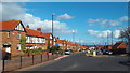
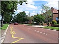
Leechmere Road, Sunderland
Leechmere Road in the Grangetown area of Sunderland.
Image: © Malc McDonald
Taken: 7 Mar 2014
0.16 miles
3
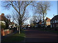
Queen Alexandra Road, Grangetown
Heading east.
Image: © JThomas
Taken: 10 Nov 2012
0.18 miles
4
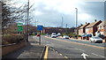
Leechmere Road, Sunderland
Leechmere Road is a dual carriageway in the southern suburbs of Sunderland.
Image: © Malc McDonald
Taken: 7 Mar 2014
0.20 miles
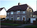
6
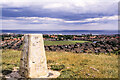
A Sunderland housing estate from Tunstall Hills
The view to the east from beside the trig point at Tunstall Hills, over housing estates, with the North Sea distant.
Image: © Trevor Littlewood
Taken: 18 Jun 2003
0.22 miles