IMAGES TAKEN NEAR TO
Angram Drive, SUNDERLAND, SR2 7RD
Introduction
This page details the photographs taken nearby to Angram Drive, SR2 7RD by members of the Geograph project.
The Geograph project started in 2005 with the aim of publishing, organising and preserving representative images for every square kilometre of Great Britain, Ireland and the Isle of Man.

There are currently over 7.5m images from over14,400 individuals and you can help contribute to the project by visiting https://www.geograph.org.uk
Image Map
Images are licensed for reuse under creativecommons.org/licenses/by-sa/2.0
Notes
- Clicking on the map will re-center to the selected point.
- The higher the marker number, the further away the image location is from the centre of the postcode.
Image Listing (12 Images Found)
Images are licensed for reuse under creativecommons.org/licenses/by-sa/2.0
Image
Details
Distance


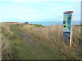
5
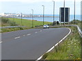
England Coast Path approaching Sunderland
Image: © Malc McDonald
Taken: 30 Oct 2016
0.23 miles
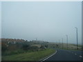
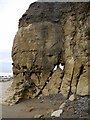
6
Salterfen Lane leading to the beach at Ryhope Nook
The lane is passing under the A1018.
Image: © Mat Fascione
Taken: 27 Aug 2017
0.23 miles
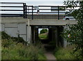
9
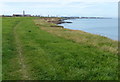
Heading north along the England Coast Path
Image: © Mat Fascione
Taken: 27 Aug 2017
0.24 miles
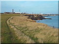
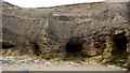
10
Cliff erosion north of Salterfen Rocks
Faults in the magnesian limestone cliffs on the Durham coast are exploited by the sea leading to caves, stacks and arches. This coastline is rapidly eroding and there are frequent rock falls and slippage of the unstable capping layer of boulder clay clearly visible in this photograph.
Image: © Andrew Curtis
Taken: 9 Oct 2009
0.24 miles