IMAGES TAKEN NEAR TO
Thornholme Road, SUNDERLAND, SR2 7JX
Introduction
This page details the photographs taken nearby to Thornholme Road, SR2 7JX by members of the Geograph project.
The Geograph project started in 2005 with the aim of publishing, organising and preserving representative images for every square kilometre of Great Britain, Ireland and the Isle of Man.

There are currently over 7.5m images from over14,400 individuals and you can help contribute to the project by visiting https://www.geograph.org.uk
Image Map
Images are licensed for reuse under creativecommons.org/licenses/by-sa/2.0
Notes
- Clicking on the map will re-center to the selected point.
- The higher the marker number, the further away the image location is from the centre of the postcode.
Image Listing (7 Images Found)
Images are licensed for reuse under creativecommons.org/licenses/by-sa/2.0
Image
Details
Distance
1
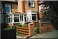
Ashwood Terrace, Sunderland
view of house in Ashwood Terrace, Sunderland
Image: © Bob Scarlett
Taken: 31 Aug 2007
0.10 miles
2
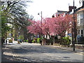
Spring colour on Tunstall Road, Sunderland
Spring blossom on trees along Tunstall Road in Sunderland, photographed on Easter Sunday in 2019.
Image: © Malc McDonald
Taken: 21 Apr 2019
0.18 miles
3
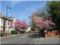
Spring colour on Tunstall Road, Sunderland
Spring blossom adding colour on Tunstall Road, in the Ashbrooke area of Sunderland, on Easter Sunday 2019.
Image: © Malc McDonald
Taken: 21 Apr 2019
0.20 miles
4
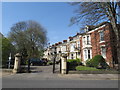
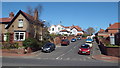
Belle Vue Park, Sunderland
Belle Vue Park is a gated cul-de-sac in the Ashbrooke area of Sunderland.
Image: © Malc McDonald
Taken: 21 Apr 2019
0.22 miles
6
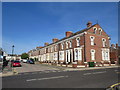
Azalea Terrace North, Sunderland
Azalea Terrace North is a residential street in Sunderland.
Image: © Malc McDonald
Taken: 20 Sep 2019
0.24 miles
7
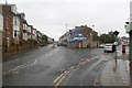
Durham Road, Sunderland
Junction with Eden House Road.
Image: © Richard Webb
Taken: 9 Aug 2016
0.25 miles