IMAGES TAKEN NEAR TO
Carlyon Street, SUNDERLAND, SR2 7DB
Introduction
This page details the photographs taken nearby to Carlyon Street, SR2 7DB by members of the Geograph project.
The Geograph project started in 2005 with the aim of publishing, organising and preserving representative images for every square kilometre of Great Britain, Ireland and the Isle of Man.

There are currently over 7.5m images from over14,400 individuals and you can help contribute to the project by visiting https://www.geograph.org.uk
Image Map
Images are licensed for reuse under creativecommons.org/licenses/by-sa/2.0
Notes
- Clicking on the map will re-center to the selected point.
- The higher the marker number, the further away the image location is from the centre of the postcode.
Image Listing (30 Images Found)
Images are licensed for reuse under creativecommons.org/licenses/by-sa/2.0
Image
Details
Distance
1
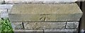
Ordnance Survey Cut Mark
This OS cut mark can be found on the south face of St George's Church Hall. It marks a point 40.300m above mean sea level.
Image: © Adrian Dust
Taken: 20 Sep 2018
0.05 miles
2
Stockton Road
St. George's church is just ahead on the left.
Image: © DS Pugh
Taken: 11 Jun 2010
0.06 miles
3
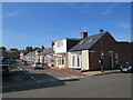
Azalea Terrace South, Sunderland
Blocks of low-rise flats on Azalea Terrace South, in Sunderland.
Image: © Malc McDonald
Taken: 20 Sep 2019
0.07 miles
4
Azalea Terrace North, Sunderland
Azalea Terrace North is a residential street in Sunderland.
Image: © Malc McDonald
Taken: 20 Sep 2019
0.10 miles
5
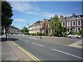
The Avenue
Looking along The Avenue, in the Grangetown area of Sunderland.
Image: © DS Pugh
Taken: 11 Jun 2010
0.10 miles
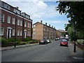
6
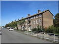
The Avenue
Elegant Edwardian/Victorian terraced houses near the City centre.
Image: © Oliver Dixon
Taken: 15 Nov 2016
0.11 miles
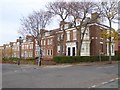
7
The Elms
A substantial terrace serviced by a private road.
Image: © Bill Boaden
Taken: 22 Apr 2017
0.11 miles
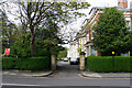
8
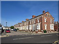
The Avenue
Quite a grand row of houses. This is the beginning of a restricted parking zone.
Image: © Bill Boaden
Taken: 22 Apr 2017
0.14 miles
9
Ordnance Survey Cut Mark
This OS cut mark can be found on the SW angle of Park Road Methodist Church. It marks a point 41.041m above mean sea level.
Image: © Adrian Dust
Taken: 20 Sep 2018
0.15 miles
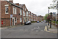
10
Ennerdale, Sunderland
Ennerdale is a residential street in Sunderland. The housing in this image is Sunderland cottages, built as single-storey dwellings although some have had loft conversions to create more living/sleeping space.
Image: © Malc McDonald
Taken: 20 Sep 2019
0.15 miles