IMAGES TAKEN NEAR TO
Stockton Road, SUNDERLAND, SR2 7AQ
Introduction
This page details the photographs taken nearby to Stockton Road, SR2 7AQ by members of the Geograph project.
The Geograph project started in 2005 with the aim of publishing, organising and preserving representative images for every square kilometre of Great Britain, Ireland and the Isle of Man.

There are currently over 7.5m images from over14,400 individuals and you can help contribute to the project by visiting https://www.geograph.org.uk
Image Map
Images are licensed for reuse under creativecommons.org/licenses/by-sa/2.0
Notes
- Clicking on the map will re-center to the selected point.
- The higher the marker number, the further away the image location is from the centre of the postcode.
Image Listing (47 Images Found)
Images are licensed for reuse under creativecommons.org/licenses/by-sa/2.0
Image
Details
Distance
1
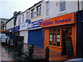
Shops on Blandford Street
Cosy row of shops featuring the only worthwhile stop on this jaunt-
the impeccable Gillies Restaurant.
Image: © MSX
Taken: 4 Dec 2005
0.03 miles
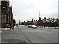
2

St Bede's Terrace, Sunderland
View taken looking south from Mowbray Park.
Image: © Stephen McKay
Taken: Unknown
0.03 miles
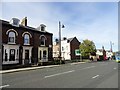
3
Stockton Road, Sunderland
A street on the west side of the city centre, running south past the University Civil Engineering department.
Image: © Robert Graham
Taken: 26 Jun 2013
0.03 miles
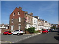
4
Grange Terrace
Nice old building, probably Victorian. Now a commercial property, it may have been a town house originally. Just along the road from Park Lane Bus Station.
Image: © Robert Graham
Taken: 3 Oct 2016
0.04 miles
5

Argyle Street
At the junction with Grange Terrace, looking east. This residential street is right next to the city centre of Sunderland.
Image: © Robert Graham
Taken: 3 Oct 2016
0.05 miles
6
Argyle Street, Sunderland
Terraced housing on Argyle Street, close to the centre of Sunderland.
Image: © Malc McDonald
Taken: 20 Sep 2019
0.07 miles
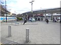
7
Park Lane Metro station, Tyne & Wear
Opened in 2002 by Tyne and Wear Metro.
Forecourt. The platforms are below the current ground level. In the background is the bus station.
Adjacent to the site of Fawcett Street railway station (1853-1879), now mostly buried under the Civic Centre.
Image: © Nigel Thompson
Taken: 10 Jan 2017
0.08 miles
8
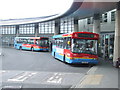
Buses in Park Lane Interchange
Sunderland's Park Lane Interchange, opened in 2002, replaced a previous bus station and depot on the same site.
Image: © Malc McDonald
Taken: 3 May 2008
0.09 miles
9
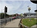
Entrance to Park Lane Bus Station
The main bus station for Sunderland city centre, it also incorporates a metro station. Pictured from Stockton Road.
Image: © Robert Graham
Taken: 26 Jun 2013
0.09 miles
10
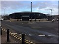
Park Lane Interchange
This handsome bus and coach station built in 1999 is allegedly the busiest bus station in Britain outside London. It adjoins a station on the Tyne and Wear Metro.
Image: © Oliver Dixon
Taken: 23 Feb 2016
0.09 miles