IMAGES TAKEN NEAR TO
Western Hill, SUNDERLAND, SR2 0AA
Introduction
This page details the photographs taken nearby to Western Hill, SR2 0AA by members of the Geograph project.
The Geograph project started in 2005 with the aim of publishing, organising and preserving representative images for every square kilometre of Great Britain, Ireland and the Isle of Man.

There are currently over 7.5m images from over14,400 individuals and you can help contribute to the project by visiting https://www.geograph.org.uk
Image Map
Images are licensed for reuse under creativecommons.org/licenses/by-sa/2.0
Notes
- Clicking on the map will re-center to the selected point.
- The higher the marker number, the further away the image location is from the centre of the postcode.
Image Listing (8 Images Found)
Images are licensed for reuse under creativecommons.org/licenses/by-sa/2.0
Image
Details
Distance
1
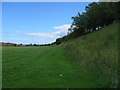
Green area between Grangetown and Ryhope
looking along the bank at the Green area between Grangetown and Ryhope
Image: © Graham Scarborough
Taken: 14 Jul 2007
0.07 miles
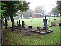
2
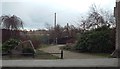
Ryhope Colliery Memorial Garden
Coal mining was undertaken at Ryhope, south of Sunderland, from 1859 until the colliery closed in 1966. The site of the miners' union office is now a memorial garden. Mining could be a dangerous occupation, 119 miners were killed in accidents at Ryhope Colliery.
Image: © Malc McDonald
Taken: 7 Mar 2014
0.12 miles
3
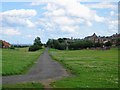
National Cycle Route 1
This path forms part of the National Cycle Route 1 as it runs through a green area between Grangetown and Ryhope
Image: © Graham Scarborough
Taken: 14 Jul 2007
0.14 miles
4
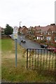
Ryeview Road, Ryhope
The red white and black symbols on the dog notice are somewhat unfortunate looking.
Image: © Richard Webb
Taken: 9 Aug 2016
0.15 miles
5
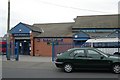
Tunstall old fire station
Tunstall old fire station, Burdon Lane, Tunstall, Tyne & Wear, now used as the Blue Watch Youth Centre
Image: © Kevin Hale
Taken: 4 Jun 2009
0.20 miles
6
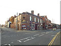
The Guide Post, Ryhope
The Guide Post pub in Ryhope, near Sunderland.
Image: © Malc McDonald
Taken: 30 Oct 2016
0.23 miles
8
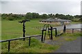
Millennium milepost, Ryhope
On the site of Ryhope Colliery which closed in 1966. There is one of the rather annoying A gates here on a cycle path. They are supposed to keep motorbikes off the path but are probably more efficient at excluding the disabled.
Image: © Richard Webb
Taken: 9 Aug 2016
0.24 miles