IMAGES TAKEN NEAR TO
The Bridges, SUNDERLAND, SR1 3LG
Introduction
This page details the photographs taken nearby to The Bridges, SR1 3LG by members of the Geograph project.
The Geograph project started in 2005 with the aim of publishing, organising and preserving representative images for every square kilometre of Great Britain, Ireland and the Isle of Man.

There are currently over 7.5m images from over14,400 individuals and you can help contribute to the project by visiting https://www.geograph.org.uk
Image Map
Images are licensed for reuse under creativecommons.org/licenses/by-sa/2.0
Notes
- Clicking on the map will re-center to the selected point.
- The higher the marker number, the further away the image location is from the centre of the postcode.
Image Listing (171 Images Found)
Images are licensed for reuse under creativecommons.org/licenses/by-sa/2.0
Image
Details
Distance
1
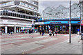
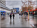
Sunderland, Market Place and Shopping Centre
Image: © David Dixon
Taken: 24 Mar 2016
0.01 miles
2
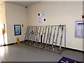
Cycle racks in the vestibule of Sunderland Railway Station
Image: © Oliver Dixon
Taken: 25 Mar 2019
0.02 miles
3
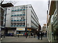
Phoenix House, Union Street, Sunderland, 18th March 2005.
This is a former World War Two bomb site.
Image: © Martin Routledge
Taken: 18 Mar 2005
0.03 miles
4
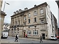
Barclays Bank, Fawcett Street, Sunderland
Grade II listed. Listing number 1208231. Bank. 1875. By Austin and Johnson for Wood's Bank. Now Barclays Bank. Baroque palazzo style.
Image: © Andrew Abbott
Taken: 29 May 2019
0.04 miles
7
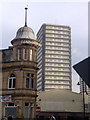
Londonderry pub in Sunderland, with multistorey flat in background
The difference in architecture styles with 70 years of "progress" between them!
Image: © Freethinker
Taken: 16 Jan 2009
0.04 miles
8
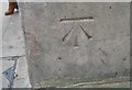
Ordnance Survey Cut Mark
This OS cut mark can be found on No53 Fawcett Street. It marks a point 33.114m above mean sea level.
Image: © Adrian Dust
Taken: 20 Sep 2018
0.05 miles
9

Sunderland station, with Newcastle - Middlesbrough express
View westward, towards Newcastle: ex-NER 'Coast' main line: Newcastle - Sunderland - West Hartlepool - Stockton and the South. The train is headed by a Gresley B16/2 rebuild (1/40) of a Raven B16/1 No.846 built 3/20, renumbered in 1946 No. 1406, then 61475 in 1949 by BR, withdrawn 4/63. The station was badly damaged by enemy action in 1943 and was already re-roofed in 1953, rebuilt in 1965.
Image: © Ben Brooksbank
Taken: 27 Jun 1953
0.05 miles
10
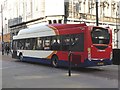
Biogas-fuelled bus in Fawcett Street
The distinctive superstructure indicates that this is one of 40 buses in the local Stagecoach fleet powered by bio-gas.
Image: © Oliver Dixon
Taken: 25 Mar 2019
0.06 miles