IMAGES TAKEN NEAR TO
Athenaeum Street, SUNDERLAND, SR1 3HP
Introduction
This page details the photographs taken nearby to Athenaeum Street, SR1 3HP by members of the Geograph project.
The Geograph project started in 2005 with the aim of publishing, organising and preserving representative images for every square kilometre of Great Britain, Ireland and the Isle of Man.

There are currently over 7.5m images from over14,400 individuals and you can help contribute to the project by visiting https://www.geograph.org.uk
Image Map
Images are licensed for reuse under creativecommons.org/licenses/by-sa/2.0
Notes
- Clicking on the map will re-center to the selected point.
- The higher the marker number, the further away the image location is from the centre of the postcode.
Image Listing (148 Images Found)
Images are licensed for reuse under creativecommons.org/licenses/by-sa/2.0
Image
Details
Distance
1

Sunderland railway station
Built in 1965 to the designs of British Rail Architects' Department.
Image: © Andrew Abbott
Taken: 29 May 2019
0.01 miles
2
Sunderland railway station
Dating from 1965, built to the designs of the British Rail Architects' Department.
Image: © Andrew Abbott
Taken: 29 May 2019
0.02 miles
3

Sunderland Railway Station
Not one of the finest, either architecturally or functionally .
Image: © Chris Morgan
Taken: 20 Feb 2020
0.02 miles
4
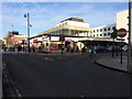
Sunderland (Central) railway station, Tyne & Wear
Opened in 1879 by the North Eastern Railway, this station replaced numerous smaller termini that had existed around the town centre.
View north at the forecourt. The platforms are underneath but until the Second World War, there was an overall roof where the block of buildings behind the station entrance now are. War damage to this was never repaired, it was removed and eventually the whole station area was built over, making the platform area distinctly gloomy.
Image: © Nigel Thompson
Taken: 10 Jan 2017
0.02 miles
5
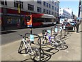
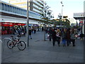
Going green in Fawcett Street
In the foreground, cycle racks. On the far side of the street, the distinctive superstructure indicates that this is one of 40 buses in the local Stagecoach fleet powered by bio-gas.
Image: © Oliver Dixon
Taken: 25 Mar 2019
0.03 miles
6
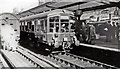
Derby light-weight two-car Diesel unit at Sunderland, on trial 1954
View northward, towards Newcastle on a trial run of a unit to Saltburn in October 1954, shortly before their introduction to the line in regular service.
Image: © Walter Dendy, deceased
Taken: 21 Oct 1954
0.04 miles
7
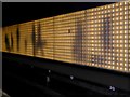
Light Wall, Sunderland Station
Sunderland station is entirely underground and hence has a rather gloomy appearance. To alleviate this gloom, Nexus, the Tyne and Wear transportation authority, embarked on a "Station of Light" project. One striking feature of this project was the 140-metre animated ‘light wall’ created by Jason Bruges along the length of platforms 3 and 4, with an ever-changing display of moving figures powered by thousands of individual LED units.
Image: © Oliver Dixon
Taken: 16 Feb 2016
0.04 miles
8
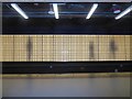
Light Wall, Sunderland Station
Sunderland station is entirely underground and hence has a rather gloomy appearance. To alleviate this gloom, Nexus, the Tyne and Wear transportation authority, embarked on a "Station of Light" project. One striking feature of this project was the 140-metre animated ‘light wall’ created by Jason Bruges along the length of platforms 3 and 4, with an ever-changing display of moving figures powered by thousands of individual LED units.
Image: © Oliver Dixon
Taken: 23 Feb 2016
0.04 miles