IMAGES TAKEN NEAR TO
John Street, SUNDERLAND, SR1 1QN
Introduction
This page details the photographs taken nearby to John Street, SR1 1QN by members of the Geograph project.
The Geograph project started in 2005 with the aim of publishing, organising and preserving representative images for every square kilometre of Great Britain, Ireland and the Isle of Man.

There are currently over 7.5m images from over14,400 individuals and you can help contribute to the project by visiting https://www.geograph.org.uk
Image Map
Images are licensed for reuse under creativecommons.org/licenses/by-sa/2.0
Notes
- Clicking on the map will re-center to the selected point.
- The higher the marker number, the further away the image location is from the centre of the postcode.
Image Listing (143 Images Found)
Images are licensed for reuse under creativecommons.org/licenses/by-sa/2.0
Image
Details
Distance
1
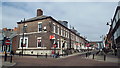
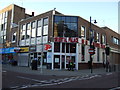
John Street, Sunderland
John Street, in the centre of Sunderland. The "no entry" signs indicate that this street, and the one to the left, are one-way streets.
Image: © Malc McDonald
Taken: 19 Apr 2014
0.02 miles
2
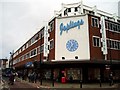
Joplings Department Store, John Street, Sunderland, 18th March 2005.
This is a former World War Two bomb site.
Image: © Martin Routledge
Taken: 18 Mar 2005
0.03 miles


5
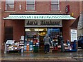
Off licence on St Thomas Street
I wonder if it was named before or after the eponymous singer's sad end?
Image: © Graham Hogg
Taken: 21 Nov 2012
0.04 miles

9
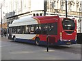
Biogas-fuelled bus in Fawcett Street
The distinctive superstructure indicates that this is one of 40 buses in the local Stagecoach fleet powered by bio-gas.
Image: © Oliver Dixon
Taken: 25 Mar 2019
0.06 miles
10
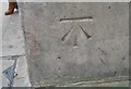
Ordnance Survey Cut Mark
This OS cut mark can be found on No53 Fawcett Street. It marks a point 33.114m above mean sea level.
Image: © Adrian Dust
Taken: 20 Sep 2018
0.06 miles