IMAGES TAKEN NEAR TO
Norfolk Street, SUNDERLAND, SR1 1EE
Introduction
This page details the photographs taken nearby to Norfolk Street, SR1 1EE by members of the Geograph project.
The Geograph project started in 2005 with the aim of publishing, organising and preserving representative images for every square kilometre of Great Britain, Ireland and the Isle of Man.

There are currently over 7.5m images from over14,400 individuals and you can help contribute to the project by visiting https://www.geograph.org.uk
Image Map
Images are licensed for reuse under creativecommons.org/licenses/by-sa/2.0
Notes
- Clicking on the map will re-center to the selected point.
- The higher the marker number, the further away the image location is from the centre of the postcode.
Image Listing (119 Images Found)
Images are licensed for reuse under creativecommons.org/licenses/by-sa/2.0
Image
Details
Distance
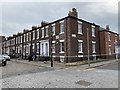
1
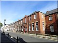
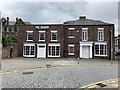
The Norfolk Hotel, Sunderland
This street is a good example of the town houses that were built in this area of the city in late Victorian times. The Norfolk Hotel is famous as being the site of a meeting in 1879 which resulted in the establishment of Sunderland Football Club. I believe that's the reason for the blue plaque on the wall.
Image: © Robert Graham
Taken: 3 Oct 2016
0.02 miles
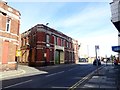
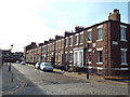
3
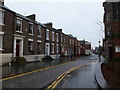
Norfolk Street
Well preserved terrace on a cobbled street close to the city centre.
Image: © Graham Hogg
Taken: 21 Nov 2012
0.03 miles
4
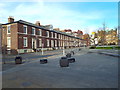
West Sunniside, Sunderland
West Sunniside, close to the centre of Sunderland.
Image: © Malc McDonald
Taken: 2 Nov 2014
0.03 miles
5
The Manor House
Grade II listed. Listing number 1291959. House, now offices and showrooms, in two builds with early C20 alterations. c1830, possibly incorporating an earlier building on the same site.
Image: © Andrew Abbott
Taken: 29 May 2019
0.03 miles
7
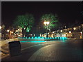
West Sunniside, Sunderland, at night
This image of West Sunniside, in Sunderland city centre, was taken late in the evening on Christmas Day 2014.
Image: © Malc McDonald
Taken: 25 Dec 2014
0.04 miles
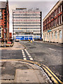
8
Warehouses on Borough Road, Sunderland
Moving east from the city centre into the former industrial areas.
Image: © Robert Graham
Taken: 3 Oct 2016
0.05 miles
9
Foyle Street, Sunderland
Foyle Street is a cobbled street close to the centre of Sunderland. This image was taken in early November sunshine, with long shadows on the ground.
Image: © Malc McDonald
Taken: 2 Nov 2014
0.05 miles
10
Foyle Street, Sunderland
Grade II listed. Listing number 1208293. Terrace of 11 houses, now offices. c1840.
Image: © Andrew Abbott
Taken: 29 May 2019
0.05 miles