IMAGES TAKEN NEAR TO
Salamander Court, TIDWORTH, SP9 7FF
Introduction
This page details the photographs taken nearby to Salamander Court, SP9 7FF by members of the Geograph project.
The Geograph project started in 2005 with the aim of publishing, organising and preserving representative images for every square kilometre of Great Britain, Ireland and the Isle of Man.

There are currently over 7.5m images from over14,400 individuals and you can help contribute to the project by visiting https://www.geograph.org.uk
Image Map
Images are licensed for reuse under creativecommons.org/licenses/by-sa/2.0
Notes
- Clicking on the map will re-center to the selected point.
- The higher the marker number, the further away the image location is from the centre of the postcode.
Image Listing (24 Images Found)
Images are licensed for reuse under creativecommons.org/licenses/by-sa/2.0
Image
Details
Distance
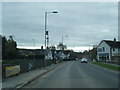
2
A3026 junction with the A338
A3026 junction with the A338
Image: © Shaun Ferguson
Taken: 27 Jun 2007
0.14 miles
3
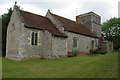
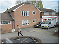
Houses, Tidworth
Looking across Pennings Road, the A338, from Holy Trinity church's graveyard.
Image: © Andrew Smith
Taken: 28 Jun 2007
0.16 miles
5
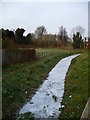
Tidworth - Frozen Stream
The recent cold weather has frozen this small stream.
Image: © Chris Talbot
Taken: 4 Jan 2009
0.19 miles
6
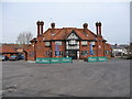
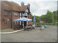
Tidworth - The Ram Public House
A popular drinking establishment which was built in 1848.
Image: © Chris Talbot
Taken: 4 Jan 2009
0.19 miles
8

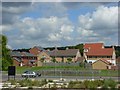
Tidworth - Houses On Pennings Road
Houses on Pennings Road.
Image: © Chris Talbot
Taken: 4 Jan 2009
0.19 miles
9
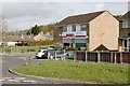
Tidworth
Spar shop off Beech Hill Road, Tidworth.
Image: © Brendan and Ruth McCartney
Taken: 10 Mar 2012
0.19 miles