IMAGES TAKEN NEAR TO
Maple Way, GILLINGHAM, SP8 4RR
Introduction
This page details the photographs taken nearby to Maple Way, SP8 4RR by members of the Geograph project.
The Geograph project started in 2005 with the aim of publishing, organising and preserving representative images for every square kilometre of Great Britain, Ireland and the Isle of Man.

There are currently over 7.5m images from over14,400 individuals and you can help contribute to the project by visiting https://www.geograph.org.uk
Image Map
Images are licensed for reuse under creativecommons.org/licenses/by-sa/2.0
Notes
- Clicking on the map will re-center to the selected point.
- The higher the marker number, the further away the image location is from the centre of the postcode.
Image Listing (16 Images Found)
Images are licensed for reuse under creativecommons.org/licenses/by-sa/2.0
Image
Details
Distance
1
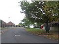
Gillingham: postbox № SP8 128, Deane Avenue
This postbox stands on the corner of Newton Close and is emptied finally at 5:15pm on weekdays and at 11:30am on Saturdays. Alongside are two drop boxes (see below).
Image: © Chris Downer
Taken: 18 Oct 2009
0.12 miles
2
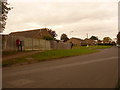
Gillingham: postbox № SP8 104, Common Mead Lane
This small postbox is emptied finally at 4:15pm on weekdays and at 9am on Saturdays.
Image: © Chris Downer
Taken: 18 Oct 2009
0.14 miles
3
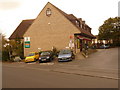
Gillingham: Wyke Post Office
Wyke Post Office used to be on Wyke Road (see Image) but moved here, within the convenience store, about 10 years ago. It is in the curiously named road, Broad Robin. The three parking spaces facing us are reserved for occupants of the flats above.
Image: © Chris Downer
Taken: 18 Oct 2009
0.14 miles
4
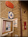
Gillingham: postbox № SP8 127, Broad Robin
This Elizabeth II-reign postbox is set into the wall of Image and is emptied finally at 5:45pm on weekdays and at 11:30am on Saturdays.
Image: © Chris Downer
Taken: 18 Oct 2009
0.14 miles
5

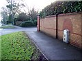
Wyke Road milestone
The plate seems to be in typical local style, with perhaps an alteration or two and a rendering. See Image] for a look at the inscription on the side.
Image: © Neil Owen
Taken: 6 Feb 2025
0.22 miles
6

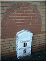
More words underneath
The milestone on Wyke Road appears to have some inscription on the side, which has been partly rendered in its past. See Image] for a location view.
Image: © Neil Owen
Taken: 6 Feb 2025
0.22 miles
7
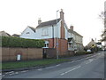
Old milestone and new housing
The milestone on Wyke Road has been respected by the new developments. See Image] for a closer look at the roadside relic.
Image: © Neil Owen
Taken: 6 Feb 2025
0.22 miles
8
Milestone, Wyke
Milestone beside the B3081, the Wyke area of Gillingham.
Image: © Maigheach-gheal
Taken: 5 Feb 2010
0.22 miles
9
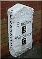
Old Milestone by the B3081, Wyke Road, Gillingham
Metal plates attached to stone post by the B3081, in parish of GILLINGHAM (NORTH DORSET District), by new road called Milestone way, by the road, on South side of road. Dorset 1 (limestone), erected by the Shaftesbury & New Road to Blandford turnpike trust in the 19th century.
Inscription reads:-
: GILLINGHAM : : Shaston / 5 / Wincanton / 6 : : GILLINGHAM :
Milestone Society National ID: DO_SHWC05.
Image: © M Dixon
Taken: 31 Jan 2003
0.22 miles
10
Milestone, Wyke
Milestone beside the B3081, the Wyke area of Gillingham. For a wider view see Image
Image: © Maigheach-gheal
Taken: 5 Feb 2010
0.22 miles