IMAGES TAKEN NEAR TO
Wyke Road, GILLINGHAM, SP8 4NF
Introduction
This page details the photographs taken nearby to Wyke Road, SP8 4NF by members of the Geograph project.
The Geograph project started in 2005 with the aim of publishing, organising and preserving representative images for every square kilometre of Great Britain, Ireland and the Isle of Man.

There are currently over 7.5m images from over14,400 individuals and you can help contribute to the project by visiting https://www.geograph.org.uk
Image Map
Images are licensed for reuse under creativecommons.org/licenses/by-sa/2.0
Notes
- Clicking on the map will re-center to the selected point.
- The higher the marker number, the further away the image location is from the centre of the postcode.
Image Listing (82 Images Found)
Images are licensed for reuse under creativecommons.org/licenses/by-sa/2.0
Image
Details
Distance
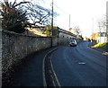
1
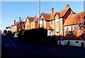
Sunlit houses and deep shadows on Wyke Road, Gillingham
Viewed just after 1pm in mid December. This is a typical scene on a sunny day in winter in the UK caused by the low elevation of the midday sun. This location is latitude 51 degrees north, which means that the noonday sun in midwinter is only about 16 degrees above the horizon compared with about 62 degrees in midsummer.
Image: © Jaggery
Taken: 13 Dec 2014
0.02 miles
2
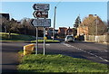
Kington Magna 3 miles to the left, Gillingham
The sign on the corner of Wyke Road points left (south) along Broad Robin.
Image: © Jaggery
Taken: 13 Dec 2014
0.04 miles
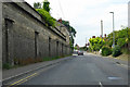
3
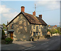
Old Toll House by the B3081, Wyke Road, Gillingham
Toll House by the B3081, in the parish of Gillingham (North Dorset District), The Old Toll House, Wyke Road, SP8 4NQ.
Grade II listed.
List Entry Number: 1324575 https://historicengland.org.uk/listing/the-list/list-entry/1324575
Surveyed
Milestone Society National ID: DO.GIL
Image: © Alan Rosevear
Taken: Unknown
0.04 miles
4
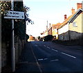
Wincanton 6 miles ahead, Gillingham
Alongside the B3081 Wyke Road in Gillingham (Dorset) 6 miles from Wincanton (south Somerset).
Image: © Jaggery
Taken: 13 Dec 2014
0.05 miles
5
Wyke Road, Gillingham
Viewed from the edge of the Common Mead Lane junction, http://www.geograph.org.uk/photo/4290534 the point where
the B3081 Wyke Street behind the camera becomes the B3081 Wyke Road ahead.
Image: © Jaggery
Taken: 13 Dec 2014
0.06 miles
6
B3081 Wyke Road, Gillingham
The massive wall, apparently partly a retaining wall, is for the grounds of Knapp House and its outbuildings and cottages.
Image: © Robin Webster
Taken: 10 Jun 2018
0.06 miles
7
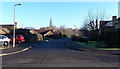
Hawthorn Avenue, Gillingham
Looking east from Coldharbour.
Image: © Jaggery
Taken: 13 Dec 2014
0.09 miles
8
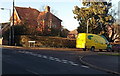
City Link van in Coldharbour, Gillingham
When I took this photo across Wyke Road on December 13th 2014, little did I realise that it would soon be of historical interest.
12 days later, on Christmas Day 2014, the BBC website announced that parcel delivery company City Link, which employs 2,727 people, had gone into administration. The Coventry-based company, owned by investment firm Better Capital, called in administrators on Christmas Eve after "substantial losses". RMT union general secretary Mick Cash told the BBC: "The way it's happened... that on Christmas Day they've done this to our members is disgraceful." Administrators warned of "substantial redundancies" over the coming days. This is because no buyer has been found to save the company. A number of staff will be retained to help return parcels to customers and help with winding down the company, said administrators Ernst & Young. City Link has stopped accepting parcels from customers at its head office and transport hub in Coventry, its three other transport hubs and 53 UK depots.
Image: © Jaggery
Taken: 13 Dec 2014
0.09 miles
9
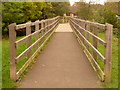
Gillingham: footbridge over the Stour, Hawthorn Avenue
This path goes south from Rolls Bridge Lane, reaching Hawthorn Avenue immediately across the bridge.
Image: © Chris Downer
Taken: 18 Oct 2009
0.10 miles
10
![Gillingham houses [35]](https://s1.geograph.org.uk/geophotos/06/08/66/6086649_d7407864_120x120.jpg)
Gillingham houses [35]
Knapp House, glimpsed in the distance is 18th century with later extensions and alterations. Listed, grade II, with details at: https://historicengland.org.uk/listing/the-list/list-entry/1110311
Image: © Michael Dibb
Taken: 14 Feb 2019
0.10 miles