IMAGES TAKEN NEAR TO
Bay Road, GILLINGHAM, SP8 4EW
Introduction
This page details the photographs taken nearby to Bay Road, SP8 4EW by members of the Geograph project.
The Geograph project started in 2005 with the aim of publishing, organising and preserving representative images for every square kilometre of Great Britain, Ireland and the Isle of Man.

There are currently over 7.5m images from over14,400 individuals and you can help contribute to the project by visiting https://www.geograph.org.uk
Image Map
Images are licensed for reuse under creativecommons.org/licenses/by-sa/2.0
Notes
- Clicking on the map will re-center to the selected point.
- The higher the marker number, the further away the image location is from the centre of the postcode.
Image Listing (11 Images Found)
Images are licensed for reuse under creativecommons.org/licenses/by-sa/2.0
Image
Details
Distance
2
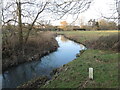
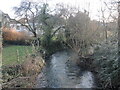
The Shreen Water north of Bay Bridge
The Shreen Water rises around the foothills of Mere, flowing south through Gillingham and on to meet with the Stour. Here the land starts to become more inhabited after the open fields.
Image: © Neil Owen
Taken: 6 Feb 2025
0.11 miles
4
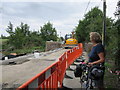
Bay Bridge
Bay road was closed due to construction work on Bay Bridge, just enough room to let cyclist and pedestrians through.
Image: © Chris McAuley
Taken: 20 Aug 2013
0.11 miles
5
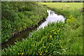
The Shreen Water at Bay
The river flows south into the centre of Gillingham from here.
Image: © Neil Owen
Taken: 6 Feb 2025
0.12 miles
6
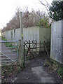
Old gate at the end of Bay Lane
The footpath must pre-date the housing, as this ornate old iron gate shows.
Image: © Neil Owen
Taken: 6 Feb 2025
0.14 miles
7
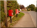
Gillingham: postbox № SP8 101, Bay Road
This little postbox is emptied finally at 5:45pm on weekdays and at 11:45am on Saturdays.
Image: © Chris Downer
Taken: 18 Oct 2009
0.18 miles
9
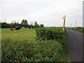
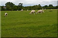
Footpath to Bowridge Hill
A view looking to the northeast from the lane between Gillingham and East Knoyle, at the start of the public footpath to Bowridge Hill.
Image: © Phil Williams
Taken: 25 Apr 2007
0.20 miles
10
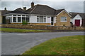
![Gillingham houses [24]](https://s3.geograph.org.uk/geophotos/06/08/58/6085811_5862a704_120x120.jpg)
Gillingham houses [24]
More houses in Bay Road.
Image: © Michael Dibb
Taken: 14 Feb 2019
0.22 miles