IMAGES TAKEN NEAR TO
South Street, GILLINGHAM, SP8 4AP
Introduction
This page details the photographs taken nearby to South Street, SP8 4AP by members of the Geograph project.
The Geograph project started in 2005 with the aim of publishing, organising and preserving representative images for every square kilometre of Great Britain, Ireland and the Isle of Man.

There are currently over 7.5m images from over14,400 individuals and you can help contribute to the project by visiting https://www.geograph.org.uk
Image Map
Images are licensed for reuse under creativecommons.org/licenses/by-sa/2.0
Notes
- Clicking on the map will re-center to the selected point.
- The higher the marker number, the further away the image location is from the centre of the postcode.
Image Listing (310 Images Found)
Images are licensed for reuse under creativecommons.org/licenses/by-sa/2.0
Image
Details
Distance
1
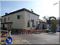
Gillingham: The Square
Looking southeast across The Square, which hardly seems much of a square at all. The Image is left of picture, and we see that a part of this old coaching inn has been separated and is occupied currently by a tandoori restaurant.
Image: © Chris Downer
Taken: 18 Oct 2009
0.00 miles
2
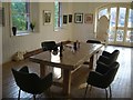
The Studio at The Slade Centre
The Studio is the main exhibition space in Gillingham. Pictured ahead of a northdorset.net editorial meeting. http://www.sladecentre.com
Image: © NDN
Taken: 6 Aug 2007
0.01 miles
3
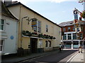
Gillingham: the Phoenix Inn
A nice pub, once a busy hotel, on the corner of The Square.
Image: © Chris Downer
Taken: 8 Aug 2009
0.01 miles
4
The Square, Gillingham
The Phoenix pub, and the Gillingham Imperial Silver Band building
Image: © Martin Hibbert
Taken: 28 Dec 2009
0.01 miles
5
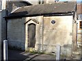
The lock up
A simple 19th century town prison. Listed, grade II, with details at: https://historicengland.org.uk/listing/the-list/list-entry/1324574
Image: © Michael Dibb
Taken: 14 Feb 2019
0.01 miles
6
![Gillingham houses [4]](https://s2.geograph.org.uk/geophotos/06/08/48/6084862_4f539bcd_120x120.jpg)
Gillingham houses [4]
Stone House was built in the 18th century as a house. A shop front was inserted in the 20th century. Listed, grade II, with details at: https://historicengland.org.uk/listing/the-list/list-entry/1324569
Image: © Michael Dibb
Taken: 14 Feb 2019
0.01 miles
7
The Square in Gillingham looking west
This used to be the road to Wyke and Wincanton, until the bypass was built. Now a dead end.
Image: © Martin Hibbert
Taken: 28 Dec 2009
0.01 miles
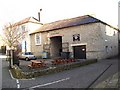
8
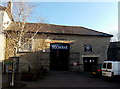
Gillingham Imperial Silver Band premises
Gillingham Imperial Silver Band's practice hall on the right used to be the Phoenix Inn's dance hall.
The band bought the premises on the corner of The Square and South Street many years ago.
Image: © Jaggery
Taken: 13 Dec 2014
0.02 miles
9
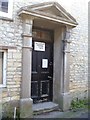
The door to the band
This neglected door set in a fine door case is where the Gillingham Imperial Silver Band reside. For details see: http://www.gisb.co.uk/
Image: © Michael Dibb
Taken: 14 Feb 2019
0.02 miles
10
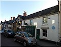
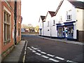
Former Gillingham Free School
There is a Gillingham Local History Society blue plaque http://www.geograph.org.uk/photo/4282200 on the High Street building on the right.
It states that Gillingham School founded as the Free School in 1516 occupied this building until 1876.
Image: © Jaggery
Taken: 13 Dec 2014
0.02 miles