IMAGES TAKEN NEAR TO
Kingsbere Lane, SHAFTESBURY, SP7 8RR
Introduction
This page details the photographs taken nearby to Kingsbere Lane, SP7 8RR by members of the Geograph project.
The Geograph project started in 2005 with the aim of publishing, organising and preserving representative images for every square kilometre of Great Britain, Ireland and the Isle of Man.

There are currently over 7.5m images from over14,400 individuals and you can help contribute to the project by visiting https://www.geograph.org.uk
Image Map
Images are licensed for reuse under creativecommons.org/licenses/by-sa/2.0
Notes
- Clicking on the map will re-center to the selected point.
- The higher the marker number, the further away the image location is from the centre of the postcode.
Image Listing (5 Images Found)
Images are licensed for reuse under creativecommons.org/licenses/by-sa/2.0
Image
Details
Distance
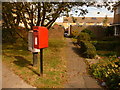
2
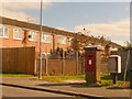
Shaftesbury: postbox № SP7 17, Wincombe Lane
An Elizabeth II-reign postbox set into a brick pillar, emptied finally at 5:45pm on weekdays and at 11:15am on Saturdays.
Image: © Chris Downer
Taken: 26 Sep 2009
0.15 miles
3
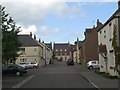
Thomas Hardy Drive
Modern housing with the appearance of being much older
Image: © Steve Sheppard
Taken: 29 Jun 2007
0.16 miles
4
Shaftesbury: postbox № SP7 18, Sweetmans Road
This small postbox is emptied finally at 5:45pm on weekdays and at 11:45am on Saturdays.
Image: © Chris Downer
Taken: 26 Sep 2009
0.20 miles