IMAGES TAKEN NEAR TO
Bugle Crescent, SHAFTESBURY, SP7 8GQ
Introduction
This page details the photographs taken nearby to Bugle Crescent, SP7 8GQ by members of the Geograph project.
The Geograph project started in 2005 with the aim of publishing, organising and preserving representative images for every square kilometre of Great Britain, Ireland and the Isle of Man.

There are currently over 7.5m images from over14,400 individuals and you can help contribute to the project by visiting https://www.geograph.org.uk
Image Map
Images are licensed for reuse under creativecommons.org/licenses/by-sa/2.0
Notes
- Clicking on the map will re-center to the selected point.
- The higher the marker number, the further away the image location is from the centre of the postcode.
Image Listing (26 Images Found)
Images are licensed for reuse under creativecommons.org/licenses/by-sa/2.0
Image
Details
Distance
8
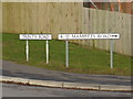
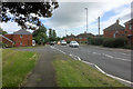
Boundary of Trinity Road and Mampitts Road
Image: © Basher Eyre
Taken: 27 Dec 2014
0.12 miles
9
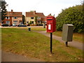
Shaftesbury: postbox № SP7 116, Mampitts Road
A small postbox, emptied finally at 5:45pm on weekdays and at noon on Saturdays. Beyond, we look along a footpath to the main A350, Christy's Lane.
Image: © Chris Downer
Taken: 26 Sep 2009
0.14 miles