IMAGES TAKEN NEAR TO
Rifles Lane, SHAFTESBURY, SP7 8GE
Introduction
This page details the photographs taken nearby to Rifles Lane, SP7 8GE by members of the Geograph project.
The Geograph project started in 2005 with the aim of publishing, organising and preserving representative images for every square kilometre of Great Britain, Ireland and the Isle of Man.

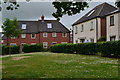
There are currently over 7.5m images from over14,400 individuals and you can help contribute to the project by visiting https://www.geograph.org.uk
Image Map
Images are licensed for reuse under creativecommons.org/licenses/by-sa/2.0
Notes
- Clicking on the map will re-center to the selected point.
- The higher the marker number, the further away the image location is from the centre of the postcode.
Image Listing (11 Images Found)
Images are licensed for reuse under creativecommons.org/licenses/by-sa/2.0
Image
Details
Distance
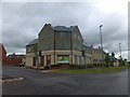
2
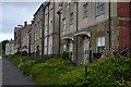
Houses facing the A30 Salisbury Road, Shaftesbury
Image: © David Martin
Taken: 31 May 2019
0.10 miles
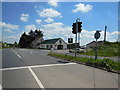
4
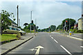
A30 traffic lights, Shaftesbury
At the junction with Greenacre Way, off to the right, a road into a large housing development extending Shaftesbury to the east.
Image: © Robin Webster
Taken: 10 Jun 2018
0.14 miles
5
New housing development by road to Wilton
Image: © David Smith
Taken: 22 Jun 2013
0.18 miles