IMAGES TAKEN NEAR TO
Bleke Street, SHAFTESBURY, SP7 8AU
Introduction
This page details the photographs taken nearby to Bleke Street, SP7 8AU by members of the Geograph project.
The Geograph project started in 2005 with the aim of publishing, organising and preserving representative images for every square kilometre of Great Britain, Ireland and the Isle of Man.

There are currently over 7.5m images from over14,400 individuals and you can help contribute to the project by visiting https://www.geograph.org.uk
Image Map
Images are licensed for reuse under creativecommons.org/licenses/by-sa/2.0
Notes
- Clicking on the map will re-center to the selected point.
- The higher the marker number, the further away the image location is from the centre of the postcode.
Image Listing (523 Images Found)
Images are licensed for reuse under creativecommons.org/licenses/by-sa/2.0
Image
Details
Distance
1
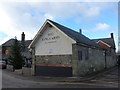
Former Drill Hall - Victoria Street
The archway leads through to a pre-WW1 drill hall used by Dorsetshire Yeomanry and Dorset Regiment.
Image: © John M
Taken: 15 Sep 2014
0.04 miles
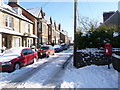
2
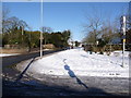
Shaftesbury: corner of Bleke and Victoria Streets
There is a small garden on the corner here, though you would not guess it today, after 6 or 7 inches of snow yesterday.
Image: © Chris Downer
Taken: 7 Feb 2009
0.04 miles
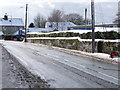
3
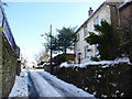
Shaftesbury: Haimes Lane
A steepish road, this section from Bleke Street at least. An ice-free route for pedestrians has been made in the tyre-tracks (left) which crosses the road behind the camera to join the pavement at the junction.
Image: © Chris Downer
Taken: 7 Feb 2009
0.04 miles
4
Shaftesbury: postbox № SP7 126, Victoria Street
This postbox is supposedly emptied at 5:45pm on weekdays and at 11:45am on Saturdays. However, I noticed that the 'Friday' next collection plate is still showing, so maybe the severe weather yesterday prevented the collection from taking place.
Image: © Chris Downer
Taken: 7 Feb 2009
0.04 miles
5
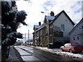
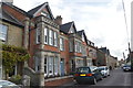
Shaftesbury: La Fleur De Lys
A restaurant on the northern side of Bleke Street, as it ascends to the town centre.
Image: © Chris Downer
Taken: 7 Feb 2009
0.04 miles
6
ACF Drill Hall - Victoria Street
Drill hall dating from pre WW1.
Image: © John M
Taken: 15 Sep 2014
0.05 miles
7
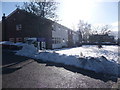
Shaftesbury: snow-topped wall and hedge, Bleke Street
Six or seven inches of snow yesterday have left this hedge and wall, on the north side Bleke Street, topped with a striking double white stripe.
Image: © Chris Downer
Taken: 7 Feb 2009
0.06 miles
8
Shaftesbury: John Shoobridge Court
A sheltered housing/retirement complex in Bleke Street, though 'sheltered' may not seem a very apt word in this weather!
Built in 1973, John Shoobridge Court comprises 19 flats and has resident staff and a community alarm service.
Image: © Chris Downer
Taken: 7 Feb 2009
0.06 miles
9
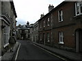
Shaftesbury-Bell Street
Towards the junction with Mustons Lane.
Image: © Ian Rob
Taken: 4 Sep 2008
0.06 miles