IMAGES TAKEN NEAR TO
Melbury Abbas, SHAFTESBURY, SP7 0DU
Introduction
This page details the photographs taken nearby to SP7 0DU by members of the Geograph project.
The Geograph project started in 2005 with the aim of publishing, organising and preserving representative images for every square kilometre of Great Britain, Ireland and the Isle of Man.

There are currently over 7.5m images from over14,400 individuals and you can help contribute to the project by visiting https://www.geograph.org.uk
Image Map
Images are licensed for reuse under creativecommons.org/licenses/by-sa/2.0
Notes
- Clicking on the map will re-center to the selected point.
- The higher the marker number, the further away the image location is from the centre of the postcode.
Image Listing (75 Images Found)
Images are licensed for reuse under creativecommons.org/licenses/by-sa/2.0
Image
Details
Distance
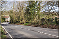
1
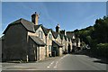
Road through Melbury Abbas
At one of its quieter moments, though there is a 20mph speed limit in force.
Image: © Chris
Taken: 14 Jun 2017
0.03 miles
2
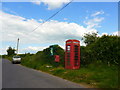
Communications hot spot in Melbury Abbas
Image: © Basher Eyre
Taken: 8 Jun 2015
0.04 miles
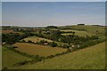
3
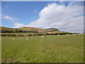
Melbury Abbas, sheep grazing
On the slopes of Melbury Hill.
Image: © Mike Faherty
Taken: 30 Mar 2013
0.04 miles
4
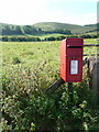
Melbury Abbas: postbox № SP7 39
This little postbox serves what would be considered the main village, while the parish has a couple outlying hamlets such as West and East Melbury which each have their own. It is emptied finally at 5pm on weekdays and at 10:30am on Saturdays.
The shapely slopes of Melbury Hill can be seen in the background.
Image: © Chris Downer
Taken: 26 Sep 2009
0.06 miles
5
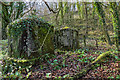
WWII Dorset - Spread Eagle Hill, Melbury Abbas - anti-tank cubes (2)
-
Image
Image: © Mike Searle
Taken: 5 Apr 2018
0.08 miles
6
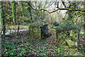
WWII Dorset - Spread Eagle Hill, Melbury Abbas: anti-tank cubes (1)
-
At Melbury Abbas on the village outskirts on Spread Eagle Hill are two anti-tank blocks on the east side of the road, and a single one opposite on the other side. Dating from the dark days of 1940 or 1941, they once may have formed part of a wartime road block on the minor road south between Melbury Abbas and Blandford.
Image
Image: © Mike Searle
Taken: 5 Apr 2018
0.08 miles
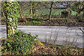
7
WWII Dorset - Spread Eagle Hill, Melbury Abbas - anti-tank cubes (4)
-
The view north towards the bottom of Spread Eagle Hill and the village of Melbury Abbas. Two of the anti-tank cubes are in woodland on the right.
Image: © Mike Searle
Taken: 5 Apr 2018
0.08 miles
8
WWII Dorset - Spread Eagle Hill, Melbury Abbas - anti-tank cubes (3)
-
The view across the road towards the two anti-tank blocks on the opposite side, with in the foreground by the tree, a single block obscured by foliage. Together they may have formed part of a wartime road block here.
Image
Image: © Mike Searle
Taken: 5 Apr 2018
0.08 miles
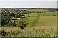
10
Across East Melbury and Melbury Abbas from Melbury Hill
Image: © Chris
Taken: 14 Jun 2017
0.09 miles