IMAGES TAKEN NEAR TO
Margaret Marsh, SHAFTESBURY, SP7 0AZ
Introduction
This page details the photographs taken nearby to SP7 0AZ by members of the Geograph project.
The Geograph project started in 2005 with the aim of publishing, organising and preserving representative images for every square kilometre of Great Britain, Ireland and the Isle of Man.

There are currently over 7.5m images from over14,400 individuals and you can help contribute to the project by visiting https://www.geograph.org.uk
Image Map
Images are licensed for reuse under creativecommons.org/licenses/by-sa/2.0
Notes
- Clicking on the map will re-center to the selected point.
- The higher the marker number, the further away the image location is from the centre of the postcode.
Image Listing (34 Images Found)
Images are licensed for reuse under creativecommons.org/licenses/by-sa/2.0
Image
Details
Distance
1
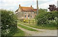
Lower Farm, Margaret Marsh
A closer view of the farmhouse visible in Image
Image: © Derek Harper
Taken: 26 May 2016
0.01 miles
2
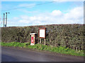
Margaret Marsh Post Box and Information Board
Image: © Maigheach-gheal
Taken: 11 Feb 2007
0.01 miles
3
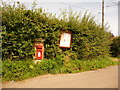
Margaret Marsh: postbox № SP7 16 and noticeboard
This Elizabeth II-reign postbox, set into a brick pillar almost opposite the lane to the church, is emptied finally at 4:30pm on weekdays and at 8:30am on Saturdays.
Image: © Chris Downer
Taken: 8 Aug 2009
0.02 miles
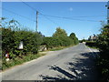
4
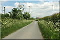
Lane, Margaret Marsh
Approaching the junction with Church Lane, the no through road on the right that leads to ... the church. Beyond is Newhouse Farm.
Image: © Derek Harper
Taken: 26 May 2016
0.03 miles
6
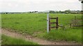
Towards Higher Farm
The large barns are at Higher Farm; on the right is Lower Farm. In the foreground is a seat I should probably have had a rest on, but I needed to press on to Shaftesbury.
Image: © Derek Harper
Taken: 26 May 2016
0.08 miles
7
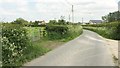
Lane, Margaret Marsh
Curving towards the junction with Church Lane, past a new extension on the right, Lower Farm on the left, and Newhouse Farm beyond the junction.
Image: © Derek Harper
Taken: 26 May 2016
0.09 miles
8
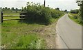
Lane, Margaret Marsh
Near Higher Farm.
Image: © Derek Harper
Taken: 26 May 2016
0.12 miles
9
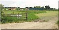
Church Farm, Margaret Marsh
From the gateway to the right of the camera in Image The church tower can be seen protruding above the barn roof.
Image: © Derek Harper
Taken: 26 May 2016
0.12 miles
10
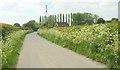
Lane, Margaret Marsh
Looking in the other direction from the same point as Image Marsh Cottages are in front of the poplars.
Image: © Derek Harper
Taken: 26 May 2016
0.15 miles