
IMAGES TAKEN NEAR TO
Whitsbury Cross, FORDINGBRIDGE, SP6 3PW
Introduction
This page details the photographs taken nearby to SP6 3PW by members of the Geograph project.
The Geograph project started in 2005 with the aim of publishing, organising and preserving representative images for every square kilometre of Great Britain, Ireland and the Isle of Man.

There are currently over 7.5m images from over14,400 individuals and you can help contribute to the project by visiting https://www.geograph.org.uk
Image Map
Images are licensed for reuse under creativecommons.org/licenses/by-sa/2.0
Notes
- Clicking on the map will re-center to the selected point.
- The higher the marker number, the further away the image location is from the centre of the postcode.
Image Listing (20 Images Found)
Images are licensed for reuse under creativecommons.org/licenses/by-sa/2.0
Image
Details
Distance
1
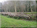
Laid hedge near Whitsbury
Laid hedges are made by bending over the samplings of the growing bush at an angle of 45 degrees. The bent saplings are woven around stakes driven into the ground at intervals of 1-2 yards. The crest is crowned by a tightly woven layer of severed rods, known as hethers, which prevent the growing wood from springing erect. Unwanted twigs and branches are removed.
Image: © Maigheach-gheal
Taken: 29 Mar 2011
0.08 miles
2
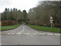
Whitsbury, byway
Minor road from Whitsbury Cross to Breamore.
Image: © Mike Faherty
Taken: 31 Mar 2010
0.11 miles
3
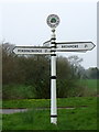
Finger post, Whitsbury Cross
The finger post seems to be new.
Image: © Maigheach-gheal
Taken: 29 Mar 2011
0.12 miles
4

Whitsbury Cross
Minor roads leading to Breamore (straight across), Whitsbury to the left, Tinkers Cross and Fordingbridge to the right and back towards Rockbourne.
Image: © Maigheach-gheal
Taken: 26 Mar 2008
0.12 miles
5
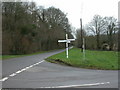
Whitsbury Cross, fingerpost
New Forest District fingerpost dated 2008, but based on a traditional Hampshire pattern; directions given to Whitsbury (from camera), Breamore, Fordingbridge & Rockbourne.
Image: © Mike Faherty
Taken: 31 Mar 2010
0.12 miles
6
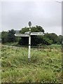
Direction Sign ? Signpost
Located on the southwest side of Whitsbury cross in Whitsbury parish. 4 arms and disc finial. See also https://www.geograph.org.uk/photo/2331232 and https://www.geograph.org.uk/photo/1287344.
Milestone Society National ID: HA_SU1317
Image: © Z La Gumina
Taken: 15 Aug 2020
0.13 miles

8

Whitsbury Cross, bridleway
Bridleway and farm road to Drove Barn and Rockbourne.
Image: © Mike Faherty
Taken: 31 Mar 2010
0.14 miles

10
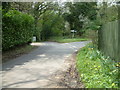
Road Junction
This junction is close to Whitsbury House.
Image: © Stuart Buchan
Taken: 29 Apr 2006
0.15 miles