IMAGES TAKEN NEAR TO
Wren Gardens, FORDINGBRIDGE, SP6 3PJ
Introduction
This page details the photographs taken nearby to Wren Gardens, SP6 3PJ by members of the Geograph project.
The Geograph project started in 2005 with the aim of publishing, organising and preserving representative images for every square kilometre of Great Britain, Ireland and the Isle of Man.

There are currently over 7.5m images from over14,400 individuals and you can help contribute to the project by visiting https://www.geograph.org.uk
Image Map (Loading...)


Getting Data...Please wait
Leaflet Map data © OpenStreetMap
Images are licensed for reuse under creativecommons.org/licenses/by-sa/2.0
Notes
- Clicking on the map will re-center to the selected point.
- The higher the marker number, the further away the image location is from the centre of the postcode.
Image Listing (7 Images Found)
Images are licensed for reuse under creativecommons.org/licenses/by-sa/2.0
Image
Details
Distance
1
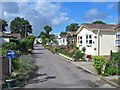
Hillbury Mobile Home Park Alderholt Dorset
Image: © Clive Perrin
Taken: 25 Aug 2005
0.07 miles
2
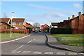
Modern housing, Wren Gardens, Alderholt, Dorset
Wren Gardens at its junction with Birchwood Drive.
Image: © Clive Perrin
Taken: 26 Mar 2009
0.09 miles
3
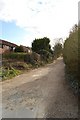
Camel Green Road, Alderholt, Dorset
This is the eastern end where it meets Hillbury road. Still unmade.
Image: © Clive Perrin
Taken: 26 Mar 2009
0.12 miles
4

Alderholt: postbox № SP6 452, Birchwood Drive
This small postbox is on the corner of Tudor Close and receives its final collection at 4:30pm on weekdays and at 8:45am on Saturdays.
Image: © Chris Downer
Taken: 15 Feb 2009
0.14 miles
5
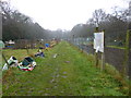
Alderholt, allotments
Off Hillbury Road.
Image: © Mike Faherty
Taken: 7 Mar 2013
0.16 miles
6
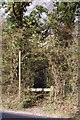
Footpath, Hillbury Road, Alderholt, Dorset
Image: © Clive Perrin
Taken: 26 Mar 2009
0.17 miles
7

Bungalow, Camel Green Road, Alderholt, Dorset
Image: © Clive Perrin
Taken: 7 Nov 2008
0.23 miles