IMAGES TAKEN NEAR TO
South Gorley, FORDINGBRIDGE, SP6 2PP
Introduction
This page details the photographs taken nearby to SP6 2PP by members of the Geograph project.
The Geograph project started in 2005 with the aim of publishing, organising and preserving representative images for every square kilometre of Great Britain, Ireland and the Isle of Man.

There are currently over 7.5m images from over14,400 individuals and you can help contribute to the project by visiting https://www.geograph.org.uk
Image Map (Loading...)


Getting Data...Please wait
Leaflet Map data © OpenStreetMap
Images are licensed for reuse under creativecommons.org/licenses/by-sa/2.0
Notes
- Clicking on the map will re-center to the selected point.
- The higher the marker number, the further away the image location is from the centre of the postcode.
Image Listing (37 Images Found)
Images are licensed for reuse under creativecommons.org/licenses/by-sa/2.0
Image
Details
Distance
1
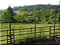
View towards Gorley Hill from Ibsley Common, New Forest
Looking north-west from the edge of Ibsley Common towards the tree-covered southern end of Gorley Hill. Huckles Brook and the South Gorley-Ogdens road run along the valley.
Image: © Jim Champion
Taken: 10 Jun 2006
0.06 miles
2
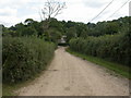
South Gorley, footpath
The western end of a footpath and track from the village to Chibden Bottom.
Image: © Mike Faherty
Taken: 13 Sep 2009
0.08 miles
3
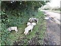
South Gorley, pannage pigs 2)
A couple of hours after Image, the sow and her litter have moved to the lane to Ogdens, and are doing what pannage pigs are supposed to - forage for acorns. http://www.thenewforest.co.uk/discover/pigs.aspx
Image: © Mike Faherty
Taken: 1 Nov 2015
0.11 miles

5
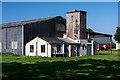
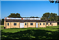
Discovering RAF Ibsley: Communal site No. 2 (2)
The laundry block and boiler house with its water tower.
Image
Image: © Mike Searle
Taken: 2 Oct 2015
0.13 miles
6
Discovering RAF Ibsley: Communal site No. 2 (3)
Surviving barrack accommodation. The taped windows are not original, but relate to WWII re-enactment displays that have taken place here in recent times.
Image
Image: © Mike Searle
Taken: 2 Oct 2015
0.13 miles
7
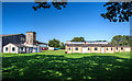
Discovering RAF Ibsley: Communal site No. 2 (1)
The smaller of the two communal sites, this site at Brooklands Farm, South Gorley, has several buildings surviving intact, among them the laundry block with its boiler house water tower, and barrack type accommodation. There were also ablution blocks, an EWS, dining room for ordinary ranks, as well as officers and sergeants messes. The accommodation on the site was used by RAF Sopley in the immediate post war period until 1951.
Image
Image: © Mike Searle
Taken: 2 Oct 2015
0.14 miles
8
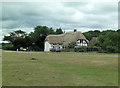
The Cottage
This late 17th early 18th C. Grade II listed cottage has English Heritage Building ID: 143644.
Image: © Stuart Logan
Taken: 16 Jul 2014
0.15 miles
9
Free roaming ponies and foals by the Old School House
New forest ponies and foals by the Old School House building.
Image: © Mat Tuck
Taken: 15 Jul 2013
0.15 miles
10
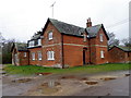
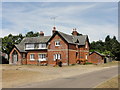
The Old School House, South Gorley
The building stands on the village green of the small village on the edge of the New Forest National Park. There is an Ordnance Survey bench mark on the south east face.
Image: © Maigheach-gheal
Taken: 24 Jan 2012
0.15 miles