IMAGES TAKEN NEAR TO
Sandleheath, FORDINGBRIDGE, SP6 1QE
Introduction
This page details the photographs taken nearby to SP6 1QE by members of the Geograph project.
The Geograph project started in 2005 with the aim of publishing, organising and preserving representative images for every square kilometre of Great Britain, Ireland and the Isle of Man.

There are currently over 7.5m images from over14,400 individuals and you can help contribute to the project by visiting https://www.geograph.org.uk
Image Map
Images are licensed for reuse under creativecommons.org/licenses/by-sa/2.0
Notes
- Clicking on the map will re-center to the selected point.
- The higher the marker number, the further away the image location is from the centre of the postcode.
Image Listing (27 Images Found)
Images are licensed for reuse under creativecommons.org/licenses/by-sa/2.0
Image
Details
Distance
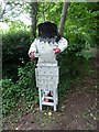
2
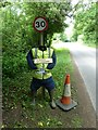
2013 Sandleheath Scarecrow Competition (a)
Image: © Basher Eyre
Taken: 17 Jun 2013
0.08 miles
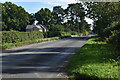
3
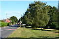
Station Road junction in Sandleheath
To the right a minor road leads to Rockbourne and to the left Alderholt.
Image: © Stuart Logan
Taken: 30 May 2012
0.09 miles
4
2013 Sandleheath Scarecrow Competition (b)
Image: © Basher Eyre
Taken: 17 Jun 2013
0.09 miles
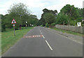
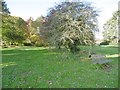
6
Bench seat and crossroads at Sandleheath
Image: © David Martin
Taken: 26 Sep 2020
0.10 miles
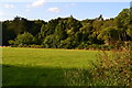
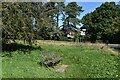
7
Sandleheath Common
A narrow strip of access land, studded with trees; next to Damerham Road.
Image: © Mike Faherty
Taken: 10 Nov 2019
0.10 miles
8
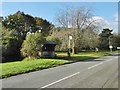
Sandleheath, bus shelter
On Main Road, next to the crossroads; offering infrequent services to Fordingbridge and Salisbury.
Image: © Mike Faherty
Taken: 10 Nov 2019
0.11 miles
9

2013 Sandleheath Scarecrow Competition (c)
Image: © Basher Eyre
Taken: 17 Jun 2013
0.11 miles