IMAGES TAKEN NEAR TO
Waverley Close, FORDINGBRIDGE, SP6 1HS
Introduction
This page details the photographs taken nearby to Waverley Close, SP6 1HS by members of the Geograph project.
The Geograph project started in 2005 with the aim of publishing, organising and preserving representative images for every square kilometre of Great Britain, Ireland and the Isle of Man.

There are currently over 7.5m images from over14,400 individuals and you can help contribute to the project by visiting https://www.geograph.org.uk
Image Map
Images are licensed for reuse under creativecommons.org/licenses/by-sa/2.0
Notes
- Clicking on the map will re-center to the selected point.
- The higher the marker number, the further away the image location is from the centre of the postcode.
Image Listing (30 Images Found)
Images are licensed for reuse under creativecommons.org/licenses/by-sa/2.0
Image
Details
Distance
1
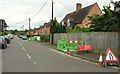
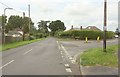
Waverley Road, Fordingbridge
A side turning seen from the Avon Valley Path as it follows Penny's Lane.
Image: © Derek Harper
Taken: 16 Jul 2016
0.03 miles
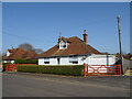
2
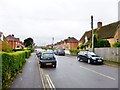
Fordingbridge, Waverley Road
Suburban road off Pennys Lane.
Image: © Mike Faherty
Taken: 15 Oct 2014
0.06 miles
4
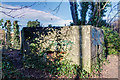
WWII Hampshire - Ringwood Stop Line, Avon Valley - Fordingbridge anti-tank island (23)
-
Penny's Lane pillbox type FW3/22: DoB ID: S0012668
Located to the north of the town alongside the public FP leading from Penny's Lane. Before the post-war housing that now occupies much of this area, it would have overlooked open ground to the north. This type 22 pillbox is concrete faced and was constructed using horizontal plank shuttering.
Image
Image: © Mike Searle
Taken: 14 Jan 2017
0.10 miles
5
Road junction, Fordingbridge
The Avon Valley Path forks right here off Whitsbury Road and along Penny's Lane.
Image: © Derek Harper
Taken: 16 Jul 2016
0.11 miles
6
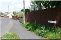
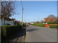
Penny's Lane
An estate road north of the town centre. The Avon Valley Path uses this road to reach the open countryside to the north.
Image: © Graham Horn
Taken: 28 Apr 2009
0.11 miles
7
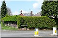
Penny's Lane
The junction of Penny's Lane with Whitsbury Road north of the town centre. This is an area of post-war bungalow and small house development.
Image: © Graham Horn
Taken: 28 Apr 2009
0.11 miles
8
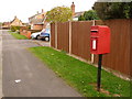
Fordingbridge: postbox № SP6 113, Burnham Road
A small postbox serving the northern extremes of the town, emptied finally at 5:30pm on weekdays and at noon on Saturdays.
Image: © Chris Downer
Taken: 21 Nov 2010
0.11 miles
10
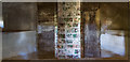
WWII Hampshire - Ringwood Stop Line, Avon Valley - Fordingbridge anti-tank island (22)
-
Sweatfords Water pillbox type FW3/22: DoB ID: S0012672
A very restricted interior view through one of the partially blocked embrasures of the unusual 'T' shape ricochet/blast wall. There's also a partial view of two of the embrasures that were easily accommodated within the very thick walls.
Image
Image: © Mike Searle
Taken: 14 Jan 2017
0.12 miles