IMAGES TAKEN NEAR TO
Orchard Close, FORDINGBRIDGE, SP6 1EN
Introduction
This page details the photographs taken nearby to Orchard Close, SP6 1EN by members of the Geograph project.
The Geograph project started in 2005 with the aim of publishing, organising and preserving representative images for every square kilometre of Great Britain, Ireland and the Isle of Man.

There are currently over 7.5m images from over14,400 individuals and you can help contribute to the project by visiting https://www.geograph.org.uk
Image Map (Loading...)


Getting Data...Please wait
Leaflet Map data © OpenStreetMap
Images are licensed for reuse under creativecommons.org/licenses/by-sa/2.0
Notes
- Clicking on the map will re-center to the selected point.
- The higher the marker number, the further away the image location is from the centre of the postcode.
Image Listing (38 Images Found)
Images are licensed for reuse under creativecommons.org/licenses/by-sa/2.0
Image
Details
Distance
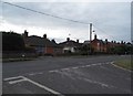
1
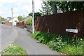
Penny's Lane
An estate road north of the town centre. The Avon Valley Path uses this road to reach the open countryside to the north.
Image: © Graham Horn
Taken: 28 Apr 2009
0.07 miles
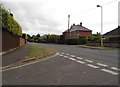
2
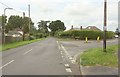
Road junction, Fordingbridge
The Avon Valley Path forks right here off Whitsbury Road and along Penny's Lane.
Image: © Derek Harper
Taken: 16 Jul 2016
0.09 miles
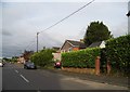
3
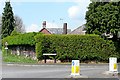
Penny's Lane
The junction of Penny's Lane with Whitsbury Road north of the town centre. This is an area of post-war bungalow and small house development.
Image: © Graham Horn
Taken: 28 Apr 2009
0.10 miles
4
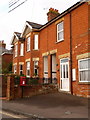
Fordingbridge: postbox № SP6 177, Whitsbury Road
This postbox stands outside what looks as if it was once a shop on the corner of Alexandra Road. It was never a post office, though. The box is emptied finally at 5:30pm on weekdays and at noon on Saturdays.
Image: © Chris Downer
Taken: 21 Nov 2010
0.10 miles
5
Salisbury Road at the junction of Lyster Road
Image: © David Howard
Taken: 16 Jun 2018
0.12 miles
7
Salisbury Road at the junction of Lyster Road
Two large trees have been removed from the front of the house opposite
Image: © David Howard
Taken: 16 Jun 2018
0.13 miles
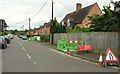
8
Alexandra Road at the junction of Whitsbury Road
Image: © David Howard
Taken: 16 Jun 2018
0.13 miles
9
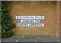
Can you see the join?
It looks like three signs but look at the lower two's borders, there was originally the one leading to sign which has been cut in half with one laid beneath the other. It was probably a different wall before and didn't fit the new one so had to divide the sign rather than waste it.
Image: © David Howard
Taken: 16 Jun 2018
0.14 miles
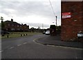
10
Waverley Road, Fordingbridge
A side turning seen from the Avon Valley Path as it follows Penny's Lane.
Image: © Derek Harper
Taken: 16 Jul 2016
0.14 miles