IMAGES TAKEN NEAR TO
Church Farm, FORDINGBRIDGE, SP6 1BQ
Introduction
This page details the photographs taken nearby to Church Farm, SP6 1BQ by members of the Geograph project.
The Geograph project started in 2005 with the aim of publishing, organising and preserving representative images for every square kilometre of Great Britain, Ireland and the Isle of Man.

There are currently over 7.5m images from over14,400 individuals and you can help contribute to the project by visiting https://www.geograph.org.uk
Image Map (Loading...)


Getting Data...Please wait
Leaflet Map data © OpenStreetMap
Images are licensed for reuse under creativecommons.org/licenses/by-sa/2.0
Notes
- Clicking on the map will re-center to the selected point.
- The higher the marker number, the further away the image location is from the centre of the postcode.
Image Listing (220 Images Found)
Images are licensed for reuse under creativecommons.org/licenses/by-sa/2.0
Image
Details
Distance
1
Hiding the wires
I suppose when you need to hide the cables that go to illuminate the church this is as good a place as any for them not to be disturbed.
Image: © Graham Horn
Taken: 28 Apr 2009
0.02 miles
2
St. Mary's church
Listed in the Domesday book of 1086, updated by the Normans around 1150 and separate north and south aisles added around 1230. The church has changed little since the 16th century. There is more information here http://www.avonvalleypartnership.org.uk/churches/fordingbridge/
Yes, the two windows are at different angles, making it very difficult to judge which is upright.
Image: © Graham Horn
Taken: 28 Apr 2009
0.02 miles
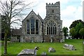
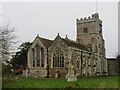
4
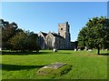
Church of St Mary the Virgin, Fordingbridge
The parish church dedicated to St Mary is mainly Early English but the tower is Perpendicular.
Image: © Maigheach-gheal
Taken: 6 Jan 2009
0.04 miles
5
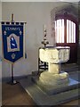
Font, Church of St Mary the Virgin, Fordingbridge
The octagonal font has a Purbeck marble bowl much damaged by exposure to the weather, with two trefoiled panels on each face. The stem is circular and the base octagonal; it probably dates from the early part of the 14th century.
Image: © Maigheach-gheal
Taken: 6 Jan 2009
0.04 miles
6

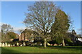
Bickton - View towards Fordingbridge
The River Avon is in the foreground. The tower of St Mary's Church, Fordingbridge, can be seen in the middle distance.
Image: © Dave Bevis
Taken: 17 Oct 2008
0.04 miles
7
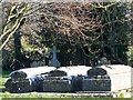
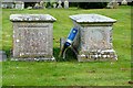
Tombs, St Mary the Virgin, Fordingbridge
Three identical family tombs.
Image: © Maigheach-gheal
Taken: 6 Jan 2009
0.04 miles
8
Fordingbridge, St. Mary's
Parish church on Church Street; C12, with C13 and later rebuilding; listed by English Heritage: http://www.imagesofengland.org.uk/Details/Default.aspx?id=143947&mode=adv
Image: © Mike Faherty
Taken: 22 Oct 2011
0.04 miles
9
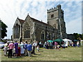
Stalls at St Mary's Church
Set up around the church are a number of small stalls selling plants, cakes and bric-a-brac, while inside of the church there are flowers and a floral carpet.
Image: © Maigheach-gheal
Taken: 4 Jun 2011
0.05 miles
10
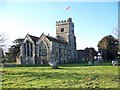
The Church of St Mary at Fordingbridge
Viewed from the north-east.
Image: © Peter Wood
Taken: 14 Feb 2017
0.05 miles