IMAGES TAKEN NEAR TO
Green Lane, SALISBURY, SP5 3SY
Introduction
This page details the photographs taken nearby to Green Lane, SP5 3SY by members of the Geograph project.
The Geograph project started in 2005 with the aim of publishing, organising and preserving representative images for every square kilometre of Great Britain, Ireland and the Isle of Man.

There are currently over 7.5m images from over14,400 individuals and you can help contribute to the project by visiting https://www.geograph.org.uk
Image Map
Images are licensed for reuse under creativecommons.org/licenses/by-sa/2.0
Notes
- Clicking on the map will re-center to the selected point.
- The higher the marker number, the further away the image location is from the centre of the postcode.
Image Listing (155 Images Found)
Images are licensed for reuse under creativecommons.org/licenses/by-sa/2.0
Image
Details
Distance
1
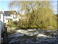
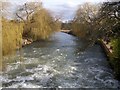
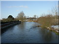
Turbulent Avon
The river is normally fairly rough here below the bridge. More so today. after extremely heavy rain last night.
Image: © Judith Green
Taken: 6 Mar 2007
0.02 miles
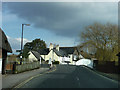
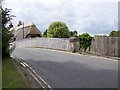
3
Bridge over the River Avon, Downton
Taken from the Avon Valley Path.
Image: © Maigheach-gheal
Taken: 4 Jul 2008
0.02 miles
4
River Avon, Downton
The brick wall is part of the recent flood defence work.
Image: © Maigheach-gheal
Taken: 4 Jul 2008
0.03 miles
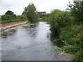
5
River Avon
Looking downstream from Downton
Image: © David Martin
Taken: 21 Mar 2010
0.03 miles
6
After the rain...
The river seems to be getting rather close to the top of the bridge arches.
Image: © Judith Green
Taken: 6 Mar 2007
0.04 miles
7
Downton Bridge
Some of the various braids of the River Avon upstream from here come together to pass under Downton Bridge, with rapids under the bridge itself.
Image: © Graham Horn
Taken: 4 Dec 2008
0.04 miles
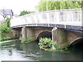
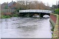
8
Downton Bridge
The bridge takes the B3080 over the River Avon. There is an Ordnance Survey bench mark on the right hand pillar.
Image: © Maigheach-gheal
Taken: 27 Jul 2010
0.05 miles
9
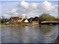
Downton, River Avon
The main branch of the Avon, looking upstream from the Iron Bridge. See also Image
Image: © Mike Faherty
Taken: 9 Jan 2010
0.05 miles
10
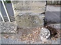
Bench Mark, Downton Bridge
The bench mark is to be found on the north side of the bridge shown in Image and for further information on the cut mark http://www.bench-marks.org.uk/bm34970
A bench mark is an Ordnance Survey arrowhead sign found on walls, bridges, churches and specially erected triangulation pillars where the altitude above sea-level has been accurately measured by surveyors. The arrowhead points to a horizontal line above it which marks the exact altitude.
With rivets and pivots there is no datum (horizontal line) cut, the pointed-to horizontal surface defining the datum height.
Image: © Maigheach-gheal
Taken: 27 Jul 2010
0.05 miles