IMAGES TAKEN NEAR TO
Old Vicarage Lane, SALISBURY, SP5 3DP
Introduction
This page details the photographs taken nearby to Old Vicarage Lane, SP5 3DP by members of the Geograph project.
The Geograph project started in 2005 with the aim of publishing, organising and preserving representative images for every square kilometre of Great Britain, Ireland and the Isle of Man.

There are currently over 7.5m images from over14,400 individuals and you can help contribute to the project by visiting https://www.geograph.org.uk
Image Map
Images are licensed for reuse under creativecommons.org/licenses/by-sa/2.0
Notes
- Clicking on the map will re-center to the selected point.
- The higher the marker number, the further away the image location is from the centre of the postcode.
Image Listing (6 Images Found)
Images are licensed for reuse under creativecommons.org/licenses/by-sa/2.0
Image
Details
Distance
1
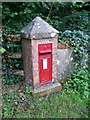
Edward VII Postbox, Alderbury
This postbox is beside Alderbury House.
Image: © Maigheach-gheal
Taken: 14 Aug 2008
0.18 miles
4

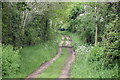
Kissing gate on footpath west of Whaddon
Image: © David Martin
Taken: 6 Jun 2010
0.24 miles
5
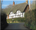
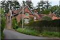
Cottage at the junction of Folley Lane & Light's Lane
Image: © Stuart Logan
Taken: 18 Mar 2012
0.24 miles