IMAGES TAKEN NEAR TO
Laverstock, SALISBURY, SP5 3BT
Introduction
This page details the photographs taken nearby to SP5 3BT by members of the Geograph project.
The Geograph project started in 2005 with the aim of publishing, organising and preserving representative images for every square kilometre of Great Britain, Ireland and the Isle of Man.

There are currently over 7.5m images from over14,400 individuals and you can help contribute to the project by visiting https://www.geograph.org.uk
Image Map (9 Images)


Leaflet Map data © OpenStreetMap
Images are licensed for reuse under creativecommons.org/licenses/by-sa/2.0
Notes
- Clicking on the map will re-center to the selected point.
- The higher the marker number, the further away the image location is from the centre of the postcode.
Image Listing (9 Images Found)
Images are licensed for reuse under creativecommons.org/licenses/by-sa/2.0
Image
Details
Distance
1
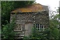
Building at Ranger's Lodge Farm
What would this have been? A workshop? Not a barn or storeroom, too many windows. Not a house, too small.
Image: © Graham Horn
Taken: 16 Aug 2008
0.05 miles
2
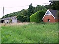
Buildings at Ranger's Lodge Farm
The Clarendon Way passes through the buildings of the farm some of which appear to be unused and neglected.
Image: © Maigheach-gheal
Taken: 16 Aug 2008
0.09 miles
3
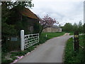
Clarendon Way entering Rangers Lodge Farm
Managed under the Countryside Stewardship scheme
Image: © Tim Heaton
Taken: 9 May 2010
0.09 miles
4
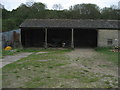
Outbuildings at Ranger's Lodge Farm
Passed on the Clarendon Way - a long distance footpath that connects Salisbury and Winchester.
Image: © Chris Heaton
Taken: 9 May 2010
0.09 miles
5
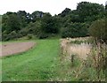
Grassy headland near Ranger's Lodge Farm
Ranger's Lodge farm is part of the Clarendon Estate.
Image: © Maigheach-gheal
Taken: 16 Aug 2008
0.11 miles
6
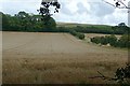
Arable land at Milford
The wheat is coming along nicely.
Image: © Graham Horn
Taken: 16 Aug 2008
0.20 miles
7
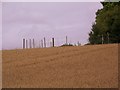
Pheasant release pen, Ranger's Lodge Farm
The release pen is situated on the corner of one of the Ranger's Belts and a wheat field.
Image: © Maigheach-gheal
Taken: 16 Aug 2008
0.21 miles
8
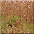
Pheasant poult near Ranger's Lodge Farm
Well grown, male pheasant poult strolls into the wheat, having posed for a photograph.
Image: © Maigheach-gheal
Taken: 16 Aug 2008
0.22 miles
9
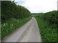
Narrow Lane near Ranger's Lodge Farm
To the east of the farm, this lane also carries the Clarendon Way on its journey towards Winchester from Salisbury.
Image: © Chris Heaton
Taken: 9 May 2010
0.24 miles